Maps of Åre kommun

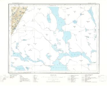
51A Bjørkvasklumpen
1 : 100000
51A Bjørkvasklumpen
1 : 100000 Johan Nordhagen | Georg Dellinger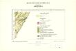
Geologisk kart 74: Bjørkvasklumpen
1 : 100000 Steinar Foslie Norges geologiske undersøkelse
51A 5; 51A 9; 51C 1; 51C 2
1 : 50000 Thorlak Aas
Mil nr 469
1 : 10000
51A Bjørkvasklumpen
1 : 100000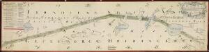
NRA GA 11
Holm | Thodal | Friedenreich | Krogh | Marelius | Ratkind
1822-4 Vera
1 : 50000 Statens kartverk
1822-4 Væren
1 : 50000 Norges Geografiske Oppmåling
1822-4 Vera
1 : 50000 Norges Geografiske Oppmåling
1822-4 Vera
1 : 50000 Statens kartverk
1822-4 Vera
1 : 50000 Statens kartverk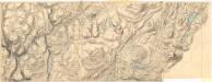
50B 8 nord; 51A 1
1 : 10000 Ditlev Wibe
Vera
1 : 250000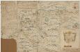
Kartblad 170: Carta over det Snee-Aasensche Hr. Major Klüwer andfortroede Compagnie
Christian Wilhelm Klüwer | Lorentz Diderich Klüwer (d.e.)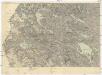
Östersund - Storlien
1 : 200000 Östersund (Švédsko) Generalstabens Litografiska Anstalt
Hotagen
1 : 100000 Generalstaben litografiska anstalt
51C Jævsjø
1 : 100000 H. Hagen | Arnt Magnus Andreassen Øgaard
50B Værdalen
1 : 100000 Oluf Lier | Johan Ferdinand Nordmann
51C Jævsjø
1 : 100000
1822-3 Bellingen
1 : 50000 Statens kartverk
1822-3 Billingen
1 : 50000 Norges Geografiske Oppmåling
1822-3 Storbellingen
1 : 50000 Statens kartverk
50B Verdal
1 : 100000
50B Verdal
1 : 100000 Oluf Lier | H. Hendriksen | Ole Tolstad
50B Verdal
1 : 100000
50B Verdal
1 : 100000 H. C. Wanggård | Ole Tolstad | Oluf Lier
50B Verdal
1 : 100000 Ole Tolstad | H. Hendriksen | Oluf Lier
Kartblad 184: Situations Carte over Wærdahlens Præstegield og det Wærdahlske Dragon Compagnie Destrict
Elling Lyng