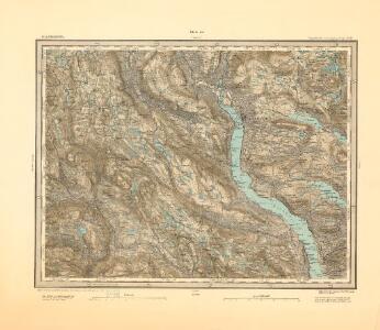
Maps of Nordre Land

25D Lillehammer
1 : 100000 Einar Sigurd Ween | Johan Ferdinand Normann
Trigonometrisk grunnlag, dublett 29- Kart over trigonometriske punkter foretatt i 1807 og 1810
Hans Lemmich Juell
Trigonometrisk grunnlag, dublett 29-2: Kart over trigonometriske punkter foretatt i 1807 og 1810
Hans Lemmich Juell
Trigonometrisk grunnlag, Squelet-Cart 29: Skelet-kart over Oppland og Hedmark 1807 og 1810
Hans Lemmich Juell
5527 Lillehammer
1 : 100000
Spesielle kart 58-1: Kart over Drammenselvens Flødningsdistrikt
1 : 100000 Thurmann | Seip
25D Lillehammer
1 : 100000 Johan Ferdinand Normann
25D Lillehammer
1 : 100000 Einar Sigurd Ween | Johan Ferdinand Normann
25D Lillehammer
1 : 100000 Johan Ferdinand Normann
25D Lillehammer
1 : 100000 Johan Ferdinand Normann | Ole Engh
25D Lillehammer
1 : 100000
1817-3 Follebu
1 : 50000 Norges Geografiske Oppmåling
1817-2 Lillehammer
1 : 50000 Statens kartverk
1817-2 Lillehammer
1 : 50000 Statens kartverk
1817-3 Follebu
1 : 50000 Statens kartverk
1817-2 Lillehammer
1 : 50000 Statens kartverk
25D Lillehammer
1 : 100000
F31 aust Synnfjell
1 : 100000
1817-2 Lillehammer
1 : 50000 Norges Geografiske Oppmåling
F31 aust Synnfjell
1 : 100000
Kartblad 5 Vey-Cart over det Nordre Hedemarkiske Capt. Von Weyhes Compagnie District
Johan Henrik Ramm
Kartblad 52: Militært Cart over det Gusdalske Compagnies District
Keilhau
F31 aust Synnfjell
1 : 100000
Kartblad 62: Charte over det Faabergske Compagnie District

F31 aust Synnfjell
1 : 100000
F31 aust Synnfjell
1 : 100000
F31 aust Synnfjell
1 : 100000
Finmarkens amt 54-3: HÃ¥ndtegnet kopi/skisse av kartlinje
1 : 200000 Gerhard Munthe, Fredrik Rode
25D 2; 25D 3; 25D 6
1 : 50000 Holmboe