Maps of Fredrikstad

9D-4-Ã ̧st
1 : 10000 Theodor Johann von Wegener
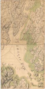
Mil nr 11
1 : 10000 von Wegener
Mil nr 11
1 : 10000 von Wegener
Gressvik i Fredrikstad
1 : 2000 Nicolai Solner Krum Krums opmaalingskontor
Fuglevik i Fredrikstad
1 : 2000 Nicolai Solner Krum Krums opmaalingskontor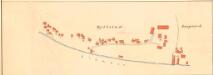
Bjølstad i Fredrikstad
1 : 2000 Nicolai Solner Krum Krums opmaalingskontor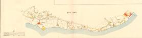
Kråkerøy
1 : 3000 Oscar Krum Krums opmaalingskontor
Nygaardsgrunden i Fredrikstad
1 : 2000 Nicolai Solner Krum Krums opmaalingskontor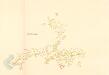
Gressvik i Fredrikstad
1 : 3000 Oscar Krum Krums opmaalingskontor
Fredrikstad
1 : 50000 Nicolai Arentz Ramm | Gerhard Munthe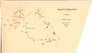
Frydenberg i Fredrikstad
1 : 2000 Nicolai Solner Krum Krums opmaalingskontor
Dammyr i Fredrikstad
1 : 2000 Nicolai Solner Krum Krums opmaalingskontor
10C 5 sør
1 : 25000 Daniel Tønnesen
Jegerkorps nr 4-2: Situationskart over en Deel af Berg, Scheberg og Borge Sogner med tilhørende Annexer, nv
1 : 13000 von Staffeldt | von Krebs | Nøkleby
10C 1
1 : 25000 Daniel Tønnesen
10C 1
1 : 20000 Ramm
Museumskart 19: Cartt over Fridrichstds havn
1 : 5000
Museumskart 33: Situation over Friderichstads havn
1 : 20000
Vaterland i Fredrikstad
1 : 1000 Den private Opmaalings lith. Anstalt. Kristiania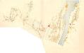
Gullbergsiden i Fredrikstad
1 : 3000 Oscar Krum Krums opmaalingskontor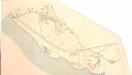
Labråten i Fredrikstad
1 : 3000 Oscar Krum Krums opmaalingskontor
Fredrikstad med omegn
1 : 100000
1913-3 Fredrikstad
1 : 50000 Statens kartverk
1913-3 Fredrikstad
1 : 50000 Norges Geografiske Oppmåling
1913-3 Fredrikstad
1 : 50000 Norges Geografiske Oppmåling
1913-3 Fredrikstad
1 : 50000 Statens kartverk
1913-3 Fredrikstad
1 : 50000 Statens kartverk
1913-3 Fredrikstad
1 : 50000 Statens kartverk
Kartblad 8-2: Militairisk Kart over det Onsøeske Compagnie District; versjon 2