Maps of Valle

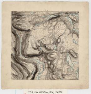
7D 12
1 : 50000 Birger Hielm
D37-8 a/2, D37-9
1 : 50000 Roald Aanrud | K. Lien
8C 9
1 : 50000 Birger Hielm | Adolf Schrà ̧der
1413-1 Urdenosi
1 : 50000 Norges Geografiske Oppmåling
1413-1 Urdenosi
1 : 50000 Statens kartverk
1413-1 Urdenosi
1 : 50000 Statens kartverk
1413-1 Urdenosi
1 : 50000 Statens kartverk
1413-2 Valle
1 : 50000 Statens kartverk
1413-2 Valle
1 : 50000 Statens kartverk
1413-2 Valle
1 : 50000 Statens kartverk
1413-2 Valle
1 : 50000 Norges Geografiske Oppmåling
D37-7, D37-8
1 : 50000 Lyder Selvik | Peter Vold | Roald Aanrud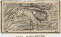
12B 4; 13A 1
1 : 100000 Paul H. Brun
Portefølje nr 13
1 : 100000 Oscar Wergeland
Portefølje nr 13
1 : 100000 Oscar Wergeland
Kroki i 100000 over trakterne Nilsebu - Urdalsnuten - Svarvarnuten - Haaheller
1 : 100000 Finn Qvale
Trigonometrisk grunnlag, Squelet-Cart 51b

Spesielle kart 80: Oversiktskart vedkommende Rensdyrsaken i Valle
F. Flate
Kart over Lister og Mandals amt
1 : 200000 Norsko Gjessing, Soren Christian Geografiske opmaaling
Statistikk 43-4- Bosettingskart over Sauda. Blad 4
1 : 250000 Statistisk Sentralbyrå
Statistikk 43-4-2: Bosettingskart over Sauda. Blad 4
1 : 250000 Statistisk Sentralbyrå
Geologisk kart over det Söndenfjeldske Norge
1 : 400000 Südwest-Blatt Kjerulf, Theodor ; Dahll, Tellef Carl Schwenzens
Trigonometrisk grunnlag, Squelet-Cart 45: Kart for 1849
F. Næser
V
1 : 400000 L. Arentz
Spesielle kart 52-1: Flaadnings-Kart over Langesundsfjordens Vasdrag
1 : 200000 Halck J. Finnes lith. Offiscin i Christiania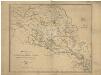
Spesielle kart 52-2: Flaadnings-kart over Langesundsfjordens vasdrag
1 : 200000 Halck J. Finnes lith. Offiscin i Christiania
Kartblad 139: Kort over det Telemarkske Regiments Distrikt
Frederik Julius Arenfeldt
V
1 : 400000 L. Arentz
Statistikk 38-2: Bosettingskart over Norge. Blad 2
Statistisk Sentralbyrå