Maps of Vegårshei

5D 11 (1/4) 8B 3 (1/2)
1 : 50000 C. C. Lund
Lunde
1 : 3000 Krum
5D 12
1 : 50000 Hans Knagenhjelm Hertzberg
5D 10 5D 11 (3/4) 8B 28B 3 (1/3)
1 : 50000 C. C. Lund
E38-5
1 : 50000 Adler Gleditsch
E38-6
1 : 50000 Axel P. Printz | Kristian Gleditsch
E38-4
1 : 50000 Toralf Øyen
5D 12
1 : 50000 Thomas Hans Knoff
5D 10 5D 11
1 : 50000 Daniel TÃ ̧nnesen
1612-2 Tvedestrand
1 : 50000 Norges Geografiske Oppmåling
1612-2 Tvedestrand
1 : 50000 Statens kartverk
1612-2 Tvedestrand
1 : 50000 Statens kartverk
1612-1 Gjerstad
1 : 50000 Statens kartverk
1612-1 Gjerstad
1 : 50000 Statens kartverk
1612-1 Gjerstad
1 : 50000 Statens kartverk
1612-1 Gjerstad
1 : 50000 Norges Geografiske Oppmåling
1612-1 Gjerstad
1 : 50000 Norges Geografiske Oppmåling
Risøy i Tvedestrand
1 : 3000 Krum
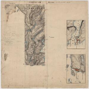
Portefølje nr 8
1 : 100000 H. Gill
Portefølje nr 8
1 : 100000 H. Gill
Museumskart 60c: Kart over strekningen Kristiansand-Risør
1 : 200000 Rasmus Iuel
Museumskart 217-23: Kart over Den Norske Kyst fra Jomfruland og Kragerø til Arendal
1 : 50000 Fehr | Vibe | C. Diriks Opmaalings Directionen
Museumskart 59: Kart over strekningen Risør-Arendal
1 : 100000 Jens Sørensen
E38 aust Gjerstad
1 : 100000
Kartblad 149: Oculair Cart over det 1ste Nedenæsske Compagnie District
E. G. Jebe
5D Arendal
1 : 100000 Ole Engh | Solem
1612-2 Tvedestrand
1 : 50000 Norges Geografiske Oppmåling
1612-2 Tvedestrand
1 : 50000 Norges Geografiske Oppmåling
5D Arendal
1 : 100000 Carl Christian Olberg | Solem