Maps of Kristiansand

5A 1
1 : 50000 Kristiansand Depotavd.
Voie
1 : 3000 Krum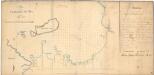
Museumskart 57: Plan af Christiansands Vestre Hanvn
1 : 1000 J. Sørensen | F. Grodtschilling | J. P. Paaske | A. N. deFontenay | E. W. Stibolt
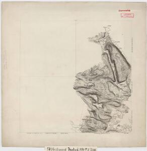
D40-5 nv/6
1 : 25000 Alf Hattestad
D40-5 nv/6
1 : 25000 Høgevold
D40-4 nø/6
1 : 25000 Erling Bjørstad
D40-5 nø/6
1 : 25000 Kaare Kvisgaard | Andreas Theodor Walle
D40-11 sø/6
1 : 25000 Alf Hattestad
Ekserserplasskart; Gimlemoen med omgivelser
1 : 25000
D40-11 sv/4
1 : 25000 Andreas Theodor Walle
Museumskart 55: Kart over Kristiansand havn
1 : 20000
Christiansand med nærmeste Omegn
1 : 10000 A. Bergh
Museumskart 58a: Carte af den Westre Hafn ved Christiansand
1 : 1000 I. Iuel
Museumskart 58b: Carte af den Westre Hafn ved Christiansand
1 : 1000 I. Iuel
Christiansands Grundtegning
1 : 20000 M. Rosing | P. Holm
5A 1 5A 2 5A 6
1 : 50000 A. Bergh
1511-3 Kristiansand
1 : 50000 Statens kartverk
1511-3 Kristiansand
1 : 50000 Norges Geografiske Oppmåling
1511-3 Kristiansand
1 : 50000 Statens kartverk
1511-3 Kristiansand
1 : 50000 Norges Geografiske Oppmåling
2C 10 5A 2
1 : 50000 Thorlak Aas
1511-3 Kristiansand
1 : 50000 Norges Geografiske Oppmåling
2C 9 5A 1
1 : 50000 Daniel TÃ ̧nnesen
1511-3 Kristiansand
1 : 50000 Statens kartverk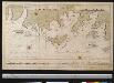
Een gedeelte van de Zuidkust van Noorwegen bij het eiland Flekkeröy en Kristansand aan het Skagerrak
Norway Gerard van Keulen
D40-4 ø/2, D40-5 v/2
1 : 25000 Alf Hattestad
D40-10 sø/4
1 : 25000 N. Houge | Andreas Theodor Walle
2C 11 5A 3
1 : 50000 Wilhelm Ernst Ramm Gran
D40-10 sø/4
1 : 25000 Kaare Kvisgaard