Maps of Namsskogan

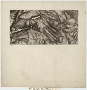
57A 1; 57A 2
1 : 50000 Jens Munthe Dahl
57A Frøiningsfjeld
1 : 100000 H. Hagen | Johan Gulbrandsen Natrud
57A Frøiningsfjeld
1 : 100000
57A Frøiningsfjeld
1 : 100000 H. Hagen | Johan Gulbrandsen Natrud
57A Frøiningsfjeld
1 : 100000 H. Hagen | Johan Gulbrandsen Natrud
57A Frøiningsfjeld
1 : 100000
57A Frøiningsfjeld
1 : 100000 Johan Gulbrandsen Natrud | H. Hagen
1824-1 Namsskogan
1 : 50000 Statens kartverk
1824-4 Kongsmoen
1 : 50000 Statens kartverk
1824-1 Namsskogan
1 : 50000
1824-1 Namsskogan
1 : 50000 Statens kartverk
1824-1 Namsskogan
1 : 50000 Statens kartverk
1824-1 Brekkvasselv
1 : 50000 Norges Geografiske Oppmåling
1824-4 Kongsmoen
1 : 50000 Norges Geografiske Oppmåling
1824-4 Kongsmoen
1 : 50000 Statens kartverk
1824-4 Kongsmoen
1 : 50000 Statens kartverk
1824-4 Kongsmoen
1 : 50000 Norges Geografiske Oppmåling
57A 6; 57A 7; 57A 10; 57A 11
1 : 50000 Ole Hagbart Bertrand Norgrenn
57A 5; 57A 9
1 : 50000 Jens Munthe Dahl
Liene
1 : 250000
Kartblad 90- Cituations Carte over det Overhaldske Præstegield og Major F. H. Sommerschields Compagnie; versjon 1
Henrich Christopher Sommerschield
Kartblad 90-2: Cituations Carte over det Overhaldske Præstegield og Major F. H. Sommerschields Compagnie; versjon 2
Henrich Christopher Sommerschield
Statistikk 43-18- Bosettingskart over Grogn. Blad 18
1 : 250000 Statistisk Sentralbyrå
Statistikk 43-18-2: Bosettingskart over Grong. Blad 18
1 : 250000 Statistisk Sentralbyrå
Kartblad 9 Situations Carte over Nummedahls Fogderi. Med Nærøeske; Fosnæske og Overhaldske Kartblad : Compagnie Districter
Henrich Christopher Sommerschield
Vega
1 : 250000
Geologisk kart 53: Geologisk Generalkart; Vega
1 : 250000 J. Rekstad Norges geologiske undersøkelse
Kartblad 71a vest: Carte over det 1. Trondhiemsche Regiment tillige med de 3 Nordenfi: Skieløber Compagniers Situation; kopi vestre del
Isach Jørgen Coldevin
Statistikk 43-19- Bosettingskart over Mosjøen. Blad 19
1 : 250000 Statistisk Sentralbyrå