Maps of Namsos

53B 5; 53B 6; 53B 9; 53B 10
1 : 50000 Thomas Hans Knoff
1723-1 Overhalla
1 : 50000 Statens kartverk
1723-1 Overhalla
1 : 50000 Statens kartverk
53B Overhalla
1 : 100000
53B Overhalla
1 : 100000
53B Overhalla
1 : 100000 Einar Sigurd Ween | Torgrim Lundtvedt
53B Overhallen
1 : 100000 Torgrim Lundtvedt | Einar Sigurd Ween
53B Overhalla
1 : 100000 Torgrim Lundtvedt | Einar Sigurd Ween
53B Overhalden
1 : 100000 Torgrim Lundtvedt | H. Hagen
53B Overhallen
1 : 100000 Torgrim Lundtvedt | H. Hagen
53B Overhalla
1 : 100000
1723-1 Overhalla
1 : 50000 Statens kartverk
1723-1 Overhalla
1 : 50000 Norges Geografiske Oppmåling
1723-1 Ranem
1 : 50000 Norges Geografiske Oppmåling
53B 1; 53B 2
1 : 50000 Jens Kristian Meinich Bratli | Lang
1724-2 Skogmo
1 : 50000 Statens kartverk
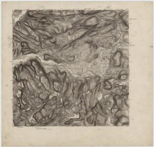
1723-4 Namsos
1 : 50000 Norges Geografiske Oppmåling
1723-4 Namsos
1 : 50000 Statens kartverk
1723-4 Namsos
1 : 50000 Statens kartverk
1723-4 Namsos
1 : 50000 Norges Geografiske Oppmåling
1723-4 Namsos
1 : 50000 Statens kartverk
53B 7; 53B 11; 53B 12
1 : 50000 Eiler Christian Holtermann
Kartblad 89: Overhaldske Compagnie
P. Q. Borg
Namsos
1 : 250000
Namsos
1 : 250000
Kartblad 90- Cituations Carte over det Overhaldske Præstegield og Major F. H. Sommerschields Compagnie; versjon 1
Henrich Christopher Sommerschield
Kartblad 87: Det Bedstadske Compagnie Districhte
Andreas Christen Bull
Kartblad 90-2: Cituations Carte over det Overhaldske Præstegield og Major F. H. Sommerschields Compagnie; versjon 2
Henrich Christopher Sommerschield
Kartblad 168: Carta over Schieløber-Compagniet og Eendeel af det Første Tronhiemsche Regiement
Christian Wilhelm Klüwer