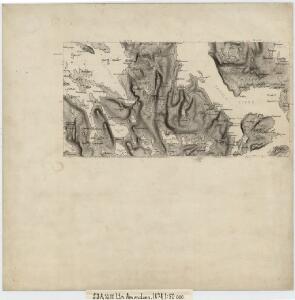
Maps of Namdalseid

53A 10; 53A 11
1 : 50000 Abraham Ludvig Amundsen
1623-1 Jössund
1 : 50000 Statens kartverk
1623-1 Sörflatanger
1 : 50000 Norges Geografiske Oppmåling
1623-1 Jøssund
1 : 50000 Statens kartverk
1623-1 Jøssund
1 : 50000 Statens kartverk
1623-1 Jössund
1 : 50000 Norges Geografiske Oppmåling
53A Namsos
1 : 100000 Torgrim Lundtvedt | Nicolai Franck
53A Namsos
1 : 100000 Torgrim Lundtvedt | Nicolai Franck
53A Namsos
1 : 100000
53A Namsos
1 : 100000 C. Pedersen | Torgrim Lundtvedt
53A Namsos
1 : 100000 Torgrim Lundtvedt | C. Pedersen
1624-2 Nord-Flatanger
1 : 50000 Norges Geografiske Oppmåling
1624-2 Nord-Flatanger
1 : 50000 Norges Geografiske Oppmåling
1624-2 Nord-Flatanger
1 : 50000 Statens kartverk
1624-2 Nord-Flatanger
1 : 50000 Statens kartverk
1624-2 Nord-Flatanger
1 : 50000 Statens kartverk
Museumskart 110: Kysten fra Kvaløya til Gjæsingan
1 : 40000 Solem
53A 1; 53A 2; 53A 5; 53A 6
1 : 50000 Abraham Ludvig Amundsen
52B 12; 53A 9
1 : 50000 Wilhelm Sørensen
1624-2 Nord-Flatanger
1 : 50000 Norges Geografiske Oppmåling
53A 12
1 : 50000 Thorvald Johan Randin Johannessen
53A 7; 53A 8
1 : 50000 Gustav Heramd
Kartblad 87: Det Bedstadske Compagnie Districhte
Andreas Christen Bull
Namsos
1 : 250000
Namsos
1 : 250000
Trigonometrisk grunnlag, Squelet-Cart 37: Trigonometrisk Kart for 1828
1 : 400000 Vibe
Kartblad 98: Situations-Cart over det Biørnørsche Compagnie District
Grønn
53C Fosnes
1 : 100000 Torgrim Lundtvedt | Johan Gulbrandsen Natrud
53C Fosnes
1 : 100000