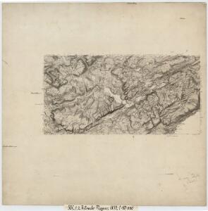
Maps of Verran

50C 1; 50C 2
1 : 50000 Johan Herman Severin Fougner
Museumskart 117: Deler av Trondheimsfjorden og Beitstadfjorden
1 : 100000 J. S. Petersen
50C Stenkjær
1 : 100000 Johan Gulbrandsen Natrud | Carl Christian Olberg
50C Steinkjer
1 : 100000
50C Stenkjær
1 : 100000 Johan Gulbrandsen Natrud | Carl Christian Olberg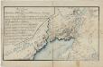
Kartblad 84: Wey-Kort over det Sparboiske Infanterie Compagnie District
Georg Friderich Coldevin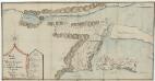
Kartblad 8 Carta over det Ytterøiske Compagnie District
Johan Andreas Klüwer
50C Steinkjer
1 : 100000
50C Steinkjer
1 : 100000 Carl Christian Olberg | Johan Gulbrandsen Natrud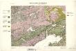
Geologiske kart 27: Den geologiske Undersøgelse, Steinkjer
1 : 100000 Theodor Kjerulf | K. M. Hauan | M. Bugge | J. Natrud Norges geologiske undersøkelse
1622-1 Verran
1 : 50000 Norges Geografiske Oppmåling
1622-1 Verran
1 : 50000 Statens kartverk
1622-1 Verran
1 : 50000 Statens kartverk
1622-1 Mosvik
1 : 50000 Statens kartverk
1622-1 Ytteröy
1 : 50000 Norges Geografiske Oppmåling
50C 5; 50C 6; 50C 9; 50C 10
1 : 50000 Johan Ferdinand Normann | Løjtnant Prytz
50A 5; 50A 6; 50A 9; 50A 10
1 : 50000 Johan Herman Severin Fougner
1623-2 Holden
1 : 50000 Norges Geografiske Oppmåling
1623-2 Holden
1 : 50000 Statens kartverk
1623-2 Holden
1 : 50000 Statens kartverk
1623-2 Holden
1 : 50000 Statens kartverk
1623-2 Sela
1 : 50000 Norges Geografiske Oppmåling
49B 12; 49D 4
1 : 50000 Fredrik Wille
1623-3 Roan
1 : 50000 Norges Geografiske Oppmåling
1623-3 Roan
1 : 50000 Statens kartverk
1622-4 Åfjord
1 : 50000 Statens kartverk
1622-4 Åfjord
1 : 50000 Statens kartverk
1622-4 Åfjord
1 : 50000 Statens kartverk
1622-4 Åfjord
1 : 50000 Norges Geografiske Oppmåling