Maps of Namdalseid

50C 11; 50C 12
1 : 50000 Abraham Ludvig Amundsen
53A 3; 53A 4
1 : 50000 Abraham Ludvig Amundsen
Kartblad 88: Vejkart over Bedstadens Compagnie District
Christian Klein dy
50C Stenkjær
1 : 100000 Johan Gulbrandsen Natrud | Carl Christian Olberg
50C Stenkjær
1 : 100000 Johan Gulbrandsen Natrud | Carl Christian Olberg
50C Steinkjer
1 : 100000
50C Steinkjer
1 : 100000
50C Steinkjer
1 : 100000 Carl Christian Olberg | Johan Gulbrandsen Natrud
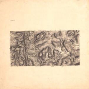
Geologiske kart 27: Den geologiske Undersøgelse, Steinkjer
1 : 100000 Theodor Kjerulf | K. M. Hauan | M. Bugge | J. Natrud Norges geologiske undersøkelse
1723-3 Steinkjer
1 : 50000 Statens kartverk
1723-3 Steinkjer
1 : 50000 Statens kartverk
1723-3 Steinkjer
1 : 50000 Statens kartverk
1723-3 Steinkjer
1 : 50000 Norges Geografiske Oppmåling
1723-3 Steinkjer
1 : 50000 Norges Geografiske Oppmåling
53A 7; 53A 8
1 : 50000 Gustav Heramd
1723-4 Namsos
1 : 50000 Norges Geografiske Oppmåling
50C 7; 50C 8
1 : 50000 Per Schielderup Nissen
1723-4 Namsos
1 : 50000 Statens kartverk
1723-4 Namsos
1 : 50000 Statens kartverk
1723-4 Namsos
1 : 50000 Norges Geografiske Oppmåling
1723-4 Namsos
1 : 50000 Statens kartverk
1623-2 Holden
1 : 50000 Norges Geografiske Oppmåling
1623-2 Holden
1 : 50000 Statens kartverk
1623-2 Holden
1 : 50000 Statens kartverk
1623-2 Sela
1 : 50000 Norges Geografiske Oppmåling
1623-2 Holden
1 : 50000 Statens kartverk
Kartblad 87: Det Bedstadske Compagnie Districhte
Andreas Christen Bull
Kartblad 168: Carta over Schieløber-Compagniet og Eendeel af det Første Tronhiemsche Regiement
Christian Wilhelm Klüwer
Namsos
1 : 250000