Maps of Levanger

50A 8 (del av); 50B 5 (del av)
1 : 50000
Kartblad 185: Carta ower det Wærdahlske Liff-Compagnie
Johan And. Klüwer
Kartblad 80: Oculair-Carte over det Wærdahlske Compagnie District
Johan Andreas Klüwer
50B 5
1 : 50000 Johannes Solem
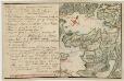
Kartblad 182: Situations Plan over Længden af det Schogenske Dragon Compagnie District
P. R. Brun
50A 8
1 : 50000 E. Lund
50A 4
1 : 50000 E. Lund
Spesielle kart 145: Rinnleiret
1 : 50000
Kartblad 184: Situations Carte over Wærdahlens Præstegield og det Wærdahlske Dragon Compagnie Destrict
Elling Lyng
1722-4 Stiklestad
1 : 50000 Norges Geografiske Oppmåling
50B 1; 50B 2; 50B 5; 50B 6
1 : 50000 Johannes Solem
50A 3; 50A 4; 50A 7; 50A 8
1 : 50000 Lund
1722-4 Stiklestad
1 : 50000 Statens kartverk
1722-4 Stiklestad
1 : 50000 Norges Geografiske Oppmåling
1722-4 Stiklestad
1 : 50000 Statens kartverk
50B Værdalen
1 : 100000 Oluf Lier | K. Petersen | H. Hagen
50B Værdalen
1 : 100000 H. Hagen | K. Petersen | Oluf Lier
Kartblad 183: Situations Carte over det Skongnske Dragon Compagnie District
Hanning | Zinche
1722-3 Levanger
1 : 50000 Statens kartverk
47C 11; 47C 12
1 : 50000 Hansen
1722-3 Levanger
1 : 50000 Norges Geografiske Oppmåling
1722-3 Levanger
1 : 50000 Statens kartverk
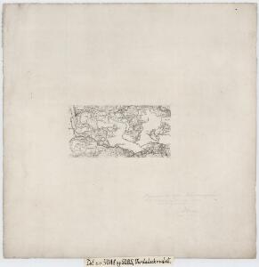
Kartblad 79: Carta ower Werdahlske Hr. Capitaine Boyes Compagnies District
Klüwer | Nicolaus Meyer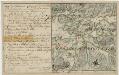
Kartblad 85: Det Sparboeske Compagnie District
Andreas Christen Bull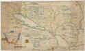
Kartblad 168: Carta over Schieløber-Compagniet og Eendeel af det Første Tronhiemsche Regiement
Christian Wilhelm Klüwer
50B Værdalen
1 : 100000 Oluf Lier | Johan Ferdinand Nordmann
50B Verdal
1 : 100000 H. C. Wanggård | Ole Tolstad | Oluf Lier
50B Verdal
1 : 100000
50B Verdal
1 : 100000