Maps of Ørland

49A 4; 49A 8; 49B 1; 49B 5
1 : 50000 Oluf Holm
49A 3; 49A 7
1 : 50000 Einar Lammers
Ekserserplasskart; Kart over traktene omkring Agdenes
1 : 100000
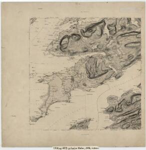
49A Ørlandet
1 : 100000 Arnt Magnus Andreassen Øgaard | H. Hagen
49A Ørland
1 : 100000
49A Ørland
1 : 100000
49A Ørland
1 : 100000
49B 2; 49B 6
1 : 50000 Hans Gjestvang
1522-4 Tarva
1 : 50000 Norges Geografiske Oppmåling
1522-3 Örland
1 : 50000 Norges Geografiske Oppmåling
1522-3 Örland
1 : 50000 Statens kartverk
1522-3 Örland
1 : 50000 Norges Geografiske Oppmåling
1522-3 Örland
1 : 50000 Statens kartverk
1522-2 Rissa
1 : 50000 Statens kartverk
1522-1 Jössund
1 : 50000 Norges Geografiske Oppmåling
1522-1 Botngård
1 : 50000 Statens kartverk
1522-2 Rissa
1 : 50000 Statens kartverk
1522-2 Rissa
1 : 50000 Statens kartverk
1522-2 Rissa
1 : 50000 Norges Geografiske Oppmåling
1522-2 Stjörna
1 : 50000 Norges Geografiske Oppmåling
1522-4 Tarva
1 : 50000 Norges Geografiske Oppmåling
1522-4 Tarva
1 : 50000 Statens kartverk
1522-4 Tarva
1 : 50000 Statens kartverk
1522-4 Tarva
1 : 50000 Statens kartverk
Kartblad 97: Cart over det Ridtzenske Compagnies District

Kartblad 96: Situations-Cart over det Redsenske Compagnie
Johan Christian Throne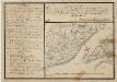
Kartblad 77- Situations Chart over det Frostensche Compagnie; versjon 1
Ebbe Carsten Hendrich Coldevin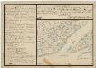
Kartblad 77-2: Situations Chart over det Frostensche Compagnie; versjon 2
Ebbe Carsten Hendrich Coldevin
Trigonometrisk grunnlag, Squelet-Cart 65-16