Maps of Hitra

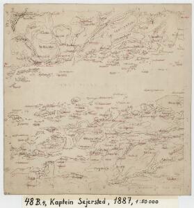
48B 4
1 : 50000 Johannes Sejersted
Museumskart 107: Specialkart over Den norske kyst fra Hitteren til Kraakvaagø og Frøien
1 : 40000 Solem
48B 4; 49A 1
1 : 50000 Fredrik Wille
48B Frøya
1 : 100000 Oluf Lier | H. Hagen
48B Frøya
1 : 100000 Oluf Lier | H. Wangård
48B Frøya
1 : 100000
48B Frøya
1 : 100000
48B Frøien
1 : 100000 H. Hagen | Oluf Lier
1422-3 Sør-Frøya
1 : 50000 Statens kartverk
1422-3 Sör-Fröya
1 : 50000 Norges Geografiske Oppmåling
1422-3 Sør-Frøya
1 : 50000 Statens kartverk
48B 3
1 : 50000 Hans Paasche Schreuder
1422-2 Hitra
1 : 50000 Statens kartverk
1422-2 Hitra
1 : 50000 Statens kartverk
1422-2 Hitra
1 : 50000 Norges Geografiske Oppmåling
1422-2 Hitra
1 : 50000 Norges Geografiske Oppmåling
48B 8; 48B 12
1 : 50000 Hans Paasche Schreuder | Ole Hagbart Bertrand Norgrenn
48B 8
1 : 50000 Johannes Sejersted
45D 8; 45D 12
1 : 50000 Fredrik Christian Sejersted
48B 3
1 : 50000 Bang
Trigonometrisk grunnlag, Squelet-Cart 56: kart over de i Sommeren 1859 bestemte Punkter
A. Heiberg
Trigonometrisk grunnlag, Squelet-Cart 65-16

Geologiske kart 121-J2: Kart med magnetisk totalfelt. Kristiansund
1 : 250000 Norges geologiske undersøkelse
Museumskart 118: Trøndelagskysten, sør-øst
1 : 200000 Paus
Norge 55-15: Accurat landcaart over Norges Rige anden Part
1 : 300000 G. Bordin
Statistikk 43-15-2: Bosettingskart over Kristiansund. Blad 15
1 : 250000 Statistisk Sentralbyrå
Statistikk 43-15- Bosettingskart over Kristiansund. Blad 15
1 : 250000 Statistisk Sentralbyrå
Statistikk 43-16- Bosettingskart over Bergen. Blad 16
1 : 250000 Statistisk Sentralbyrå
Norge 32c: Cituations Carte over en vis Bestreckning nemblig fra Trundhiem og til Opdalen
1 : 300000 J. H. Emahusen