Maps of Tydal

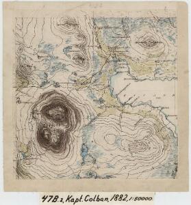
47B 2
1 : 50000 Erik Andreas Colban
47B 2; 47B 3
1 : 50000 Johan Lauritz Bull | C. Lund | Erik Andreas Colban
1721-2 Essandsjöen
1 : 50000 Norges Geografiske Oppmåling
1721-2 Essandsjö
1 : 50000 Norges Geografiske Oppmåling
43D 10; 43D 11; 47B 2; 47B 3
1 : 50000 Schilling
47B 1
1 : 50000 Johan Lauritz Bull | Schilling | Erik Andreas Colban
1721-2 Essandsjöen
1 : 50000 Norges Geografiske Oppmåling
1721-2 Esandsjøen
1 : 50000 Statens kartverk
1721-2 Esandsjøen
1 : 50000 Statens kartverk
1721-2 Essandsjöen
1 : 50000 Statens kartverk
47B Essandsjø
1 : 100000 C. Pedersen | Oluf Lier
47B Essandsjø
1 : 100000 Oluf Lier | C. Pedersen
47B Essandsjø
1 : 100000 Oluf Lier | Johan Nordhagen
47B Essandsjø
1 : 100000
47B Essandsjø
1 : 100000 Oluf Lier | Johan Nordhagen
47B Essandsjø
1 : 100000 Johan Nordhagen | Oluf Lier
47B Essandsjø
1 : 100000
Portefølje nr 72
1 : 100000 Schilling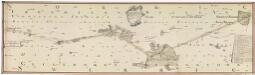
NRA GA 9
Marelius | Ratkind | Thodal | Hiarne | Krogh | Holm
47B 6; 47B 7; 47B 10; 47B 11
1 : 50000 Erik Andreas Colban | Hans Gjestvang
47B 1
1 : 50000 Erik Andreas Colban
43D 10; 43D 11
1 : 100000 Karl Sigwald Johannes Bull
47B 3
1 : 50000 Erik Andreas Colban
Portefølje nr 72
1 : 100000 Schilling
Norge 55-6: Accurat landcaart over Norges Rige anden Part
1 : 300000 G. Bordin
Trigonometrisk grunnlag, Squelet-Cart 65-14

Trondheim
1 : 250000
Geologiske kart 121-D: Kart med magnetisk totalfelt. Trondheim
1 : 250000 Norges geologiske undersøkelse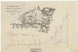
Spesielle kart 11: Oversigtskart og Profil over den projecterede Jernbanelinie fra Trondhjem til Jemtland over Meraker
1 : 400000 C. Collett