Maps of Selbu

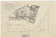
47A 2
1 : 50000 Thomas Hans Knoff
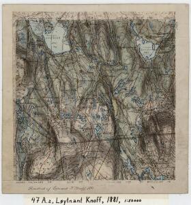
47A 2
1 : 50000 Thomas Hans Knoff
47A 1; 47A 2
1 : 50000 Thomas Hans Knoff | Johan Lauritz Bull
43C 10; 43C 11; 47A 2; 47A 3
1 : 50000 Schilling
1621-2 Selbu
1 : 50000 Statens kartverk
1621-2 Selbu
1 : 50000 Statens kartverk
1621-2 Selbu
1 : 50000 Norges Geografiske Oppmåling
1621-2 Selbu
1 : 50000 Norges Geografiske Oppmåling
1621-2 Selbu
1 : 50000 Statens kartverk
47A Selbu
1 : 100000 Harald Ingvald Johannessen | C. Pedersen
47A Selbu
1 : 100000 C. Pedersen | Harald Ingvald Johannessen
47A Selbu
1 : 100000 Harald Ingvald Johannessen | C. Pedersen
47A Selbu
1 : 100000 Johan Nordhagen | Harald Ingvald Johannessen
47A Selbu
1 : 100000 Harald Ingvald Johannessen | C. Pedersen
47A Selbu
1 : 100000 C. Pedersen | Harald Ingvald Johannessen
47A 3
1 : 50000 Thomas Hans Knoff
47A 3
1 : 50000 Thomas Hans Knoff
47A 1
1 : 50000 Schilling | Thomas Hans Knoff
Geologisk kart 36: NorgesGeologiske Undersøgelse, Rektangel 47A Selbu
1 : 100000 K. M. Hauan | C. Homan | H. Reusch | Johannessen | M. Bugge Norges geologiske undersøkelse
47A Selbu
1 : 100000 Harald Ingvald Johannessen | C. Pedersen
Portefølje nr 71
1 : 100000 Munthe
Portefølje nr 71
1 : 100000 Munthe
Kartblad 93: Carte over det Selboische Compagnie District
Carl Henning Krog
Spesielle kart 22-2: Tyvold - Rognæs
1 : 400000 Albert Cammermeyer Forlag
Norge 55-6: Accurat landcaart over Norges Rige anden Part
1 : 300000 G. Bordin
Trigonometrisk grunnlag, Squelet-Cart 65-14

Trondheim
1 : 250000
Norge 55-10: Accurat landcaart over Norges Rige anden Part
1 : 300000 G. Bordin
Geologiske kart 121-D: Kart med magnetisk totalfelt. Trondheim
1 : 250000 Norges geologiske undersøkelse