Maps of Midtre Gauldal

43C-9-nø
1 : 10000 J. Müller
43C-9-nø
1 : 10000 J. Müller
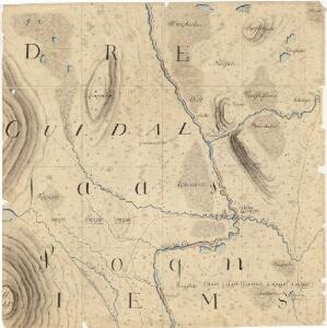
47A 1
1 : 50000 Thomas Hans Knoff | Schilling
47A 1
1 : 50000 Schilling | Thomas Hans Knoff
Kartblad nr 4b: Kaart over Postveien fra Trondheim til Røraas
1 : 20000 J. H. Reichborn
47A 1
1 : 50000 Schilling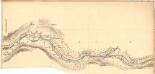
Fra Kirkvold til Hindsverk
1 : 20000 J. H. Reichborn
Portefølje nr 71
1 : 50000
43C-9-nv
1 : 10000 J. Müller
43C-9-nv
1 : 10000 J. Müller
43C-9-nv
1 : 10000 J. Müller
43C 5; 43C 6; 43C 9; 43C 10
1 : 50000 Johan Lauritz Bull
1621-2 Selbu
1 : 50000 Norges Geografiske Oppmåling
1621-2 Selbu
1 : 50000 Norges Geografiske Oppmåling
1621-2 Selbu
1 : 50000 Statens kartverk
47A Selbu
1 : 100000 Harald Ingvald Johannessen | C. Pedersen
Portefølje nr 71
1 : 100000 Munthe
Portefølje nr 71
1 : 100000 Munthe
Kartblad 93: Carte over det Selboische Compagnie District
Carl Henning Krog
Spesielle kart 22-2: Tyvold - Rognæs
1 : 400000 Albert Cammermeyer Forlag
Spesielle kart 103-1: Flötningskart over Glommens Vassdrag
1 : 1000 Einar Sigurd Ween
Kartblad 166b-1a: Wej-Cart over det Aamodske Compagnie; 166b-1a

Norge 55-6: Accurat landcaart over Norges Rige anden Part
1 : 300000 G. Bordin
Trigonometrisk grunnlag, Squelet-Cart 65-14

Røros
1 : 250000
Trondheim
1 : 250000
Norge 55-10: Accurat landcaart over Norges Rige anden Part
1 : 300000 G. Bordin
Geologiske kart 121-D: Kart med magnetisk totalfelt. Trondheim
1 : 250000 Norges geologiske undersøkelse
Spesielle kart 11: Oversigtskart og Profil over den projecterede Jernbanelinie fra Trondhjem til Jemtland over Meraker
1 : 400000 C. Collett