Maps of Tynset

37D 7; 37D 8; 37D 11; 37D 12
1 : 50000 Berthold Dahl | Einar Halle
1619-4 Kvikneskogen
1 : 50000 Statens kartverk
1619-4 Kvikneskogen
1 : 50000 Statens kartverk
1619-4 Kvikneskogen
1 : 50000 Statens kartverk
1619-4 Kvikneskogen
1 : 50000 Norges Geografiske Oppmåling
37D 11
1 : 20000 Peter Haboe Hertzberg Paludan
37D 8; 37D 12
1 : 50000 Thor Sire
37D 12
1 : 20000 Peter Haboe Hertzberg Paludan
1619-4 Röstvangen
1 : 50000 Norges Geografiske Oppmåling
37D Folldal
1 : 100000
37D Folldal
1 : 100000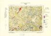
Geologisk kart 76: Foldal
1 : 100000 W. Marlow Norges geologiske undersøkelse
37D Folldal
1 : 100000
37D Foldal
1 : 100000
Geologisk kart 115: Kvartærgeologisk kart over Nord-Østerdalen
1 : 100000 C. Foyn | J. L. Sollid | T. Dalfest Geografisk institutt, Universitetet i Oslo
42B 2; 42B 3; 42B 5; 42B 6; 42B 7; 42B 8; 42B 9; 42B 10; 42B 11; 42B 12; 42D 2; 42D 3; 37D 10
1 : 100000 Ramm
37D 4; 37D 8
1 : 50000 Erling Bjørstad
38C 5
1 : 50000 Marius Widerøe
38C 9
1 : 50000 Marius Widerøe | David Ebbesen
37D 1; 37D 2; 37D 3; 37D 4; 37D 5; 37D 6; 37D 7; 37D 8; 37B 9; 37B 10; 37B 11
1 : 100000 Schilling
42B 3; 42B 4
1 : 100000 Emil Adolf Eriksen
37D 3; 37D 7
1 : 50000 Erling Bjørstad
37D 9; 37D 10
1 : 50000 Einar Halle
38C 9; 38C 10
1 : 50000 Øvergaard
Kartblad nr XI: Vei-kaart over den trondhjemske Kongevei fra Christiania til Røraas gjennom Eidsvold, Rommedal, Levthen og Østerdalen
1 : 20000 J. H. Reichborn
Spesielle kart 145: Odden
1 : 50000
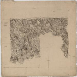
Hedemarkens amt nr 74: Carte over Tønset Hoved Sogn

Spesielle kart 22-3: Tønset - Røros
1 : 400000 Albert Cammermeyer Forlag
Spesielle kart 103-3: Flötningskart over Glommens vassdrag
1 : 1000 Einar Sigurd Ween