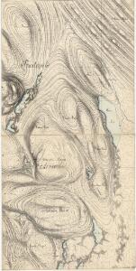
Maps of Rendalen

32C-3-øst
1 : 10000 Hans Lemmich Juell
Mil nr 253
1 : 10000 Hans Lemmich Juell
1918-2 Åkrestrømmen
1 : 50000 Statens kartverk
1918-2 Storsjöen
1 : 50000 Statens kartverk
1918-2 Storsjöen
1 : 50000 Norges Geografiske Oppmåling
1918-2 Åkrestrømmen
1 : 50000 Statens kartverk
1918-2 Storsjöen
1 : 50000 Norges Geografiske Oppmåling
32C 2; 32C 3; 32C 7
1 : 50000 Georg Peter Leganger Mamen
32C 4; 32C 8
1 : 50000 Marius Widerøe
1918-2 Storsjøen
1 : 50000
32A 11; 32A 12
1 : 50000 Severin Vincents Heiberg Segelcke
32A 11; 32A 12
1 : 50000 Severin Vincents Heiberg Segelcke
Mil nr 241
1 : 10000 Hans Lemmich Juell | Johan Henrich Ramm
Mil nr 253
1 : 10000 Hans Lemmich Juell
32C-3-vest
1 : 10000 Hans Lemmich Juell
32A 11 øst
1 : 10000 Hans Lemmich Juell
32C Ytre Rendalen
1 : 100000 Ole Tolstad | Ole Engh
Geologisk kart 89: Ytre Rendal
1 : 100000 Per Holmsen | Chr. Oftedahl E. Moestue A.S.
32C Ytre Rendal
1 : 100000 Ole Tolstad | Ole Engh
32C Ytre Rendalen
1 : 100000 Ole Engh | Ole Tolstad
Portefølje nr 48
1 : 100000 Schilling
Spesielle kart 103-7: Flötningskart over Glommens vassdrag
1 : 1000 Einar Sigurd Ween
Kartblad 166b-3: Wej-Cart over det Aamodske Compagnie; 166b-3

Østerdalen
1 : 250000
Spesielle kart 144-b: Flykart à ̃sterdalen
1 : 250000 NGO
Kartblad 164: Cituations-Chart over det Elveromsske Skieløber-Compagnies District
B. H. Todderud
Trigonometrisk grunnlag, Squelet-Cart 65-10

Norge 55- Accurat landcaart over Norges Rige anden Part
1 : 300000 G. Bordin
Trigonometrisk grunnlag, Squelet-Cart 35: Skelet-kart over de trigonometrisk bestemte Punkter Sommeren 1826
Th. Broch