Maps of Løten

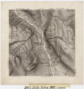
26C 4
1 : 50000 Johannes Solem
26C 4
1 : 50000 Johannes Solem
Mil nr 183
1 : 10000 Johan Henrich Ramm | Eilert Woldemar Preben Ramm
Kartblad VI: Vei-kaart over den trondhjemske Kongevei fra Christiania til Røraas gjennom Eidsvold, Rommedal, Levthen og Østerdalen
1 : 20000 J. H. Reichborn
Fra Grundset til Johannesstua
1 : 20000 J. H. Reichborn
26C 4 øst
1 : 10000
Fra Smedbakken via Terningen til Foss
1 : 20000 J. H. Reichborn
26C 4 vest
1 : 10000
Mil nr 183
1 : 10000 Johan Henrich Ramm | Eilert Woldemar Preben Ramm
26A 12 øst
1 : 10000 Heide | Johan Friderich Næser | Dorph
H32-7; H32-8
1 : 50000 Kaare Kvisgaard
H32-7; H32-8
1 : 50000 Kaare Kvisgaard
Ekserserplasskart; Terningmoen-nv
Per Hovdn
H32-9
1 : 50000 Kaare Kvisgaard
Ekserserplasskart; Terningmoen-nø
Per Hovdn
H32-9; vest
1 : 50000 Lyder Selvik | Kaare Kvisgaard | M. Gulbransen
26C 8
1 : 50000 Johannes Solem
26A 12
1 : 50000 Frithjof Jacobsen
Mil nr 184
1 : 10000
26D 1 vest
1 : 10000 Ramm | Hans Lemmich Juell
Trigonometrisk grunnlag, vedlegg 47: Fundament Mensul til Qvadrat-Miilen No 162
1 : 10000 Johan Henrich Ramm | Hans Lemmich Juell
26A 12 nord
1 : 10000 Dorph | Johan Friderich Næser | Heide
26A 12 vest
1 : 10000 Heide | Johan Friderich Næser | Dorph
Mil nr 173
1 : 10000 Johan Henrich Ramm | Hans Lemmich Juell
Ekserserplasskart; Terningmoen
1 : 10000
H32-3
1 : 50000 Erling Bjørstad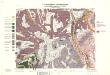
Geologisk kart 32a: Den Geologiske Undersøgelse, Rektangel 26 Åmot
1 : 100000 P. Krohn | Ths. Münster | Øgaard Norges geologiske undersøkelse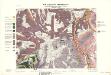
Geologisk kart 32b: Den Geologiske Undersøgelse, Rektangel 26 Åmot
1 : 100000 Øgaard | Ths. Münster | P. Krohn Norges geologiske undersøkelse
Portefølje nr 40
1 : 100000