Maps of Løten

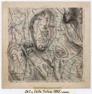
26C 3
1 : 50000 Johannes Solem
26C 3
1 : 50000 Johannes Solem
26C 3; 26C 7
1 : 50000 Ramm
H32-7; H32-8
1 : 50000 Kaare Kvisgaard
1916-1 Löten
1 : 50000 Statens kartverk
H32-7; H32-8
1 : 50000 Kaare Kvisgaard
1916-1 Löten
1 : 50000 Norges Geografiske Oppmåling
1916-1 Løten
1 : 50000 Statens kartverk
1916-1 Løten
1 : 50000 Statens kartverk
1916-1 Løten
1 : 50000 Statens kartverk
26C 7
1 : 50000 Johannes Solem
H32-1; H32-7
1 : 25000 Erik Christensen
26C 7
1 : 50000 Johannes Solem
26A 11
1 : 50000 Grimsoth
Mil nr 183
1 : 10000 Johan Henrich Ramm | Eilert Woldemar Preben Ramm
Geologisk kart 32a: Den Geologiske Undersøgelse, Rektangel 26 Åmot
1 : 100000 P. Krohn | Ths. Münster | Øgaard Norges geologiske undersøkelse
1916-1 Löten
1 : 50000 Norges Geografiske Oppmåling
Geologisk kart 32b: Den Geologiske Undersøgelse, Rektangel 26 Åmot
1 : 100000 Øgaard | Ths. Münster | P. Krohn Norges geologiske undersøkelse
26C Åmot
1 : 100000
Geologisk kart 8b: Jordbundskart over en del af Mjøsens Omegn
1 : 100000 Theodor Kjerulf | Irgens
26C Åmot
1 : 100000 C. Pedersen | Arnt Magnus Andreassen Øgaard
26C Åmot
1 : 100000 C. Pedersen | Arnt Magnus Andreassen Øgaard
26C Åmot
1 : 100000 Arnt Magnus Andreassen Øgaard | C. Pedersen
26C Åmot
1 : 100000 C. Pedersen | Arnt Magnus Andreassen Øgaard
26C Åmot
1 : 100000 Nicolai Franck | Arnt Magnus Andreassen Øgaard
1917-2 Rena
1 : 50000 Statens kartverk
Kartblad 49b: Geographisk Charte over Conturen af det Leuthenske mig Allernaadigst anbetroede Compagnie
Rick
Ekserserplasskart; Terningmoen med omgivelser
1 : 50000
26C 4
1 : 50000 Johannes Solem