Maps of Østre Toten

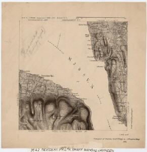
26A 2
1 : 20000 Trygve Frivold Graff-Wang | Jacob Hvinden Haug
26A 2
1 : 50000 Frithjof Jacobsen
26A 2
1 : 20000 Jørgen Scielderup Grimseth
Fra Korsøgarden til Nøkleby
1 : 20000 J. H. Reichborn
Hedemarkens amt nr 59b: Kart over Stange St. med omgivelser
1 : 2000 Nicolai Solner Krum
26A 1; 26A 2
1 : 50000
Fra Buskebakksætra til Krabysanden
J. H. Reichborn
20C 10 a
1 : 50000 Frithjof Jacobsen
26A 6
1 : 50000 Hans Knagenhjelm Hertzberg | Jacob Ager Laurantzon
Kartblad nr 1: Kaart over Postveien fra Korsødegaarden til Trondhjem igjennom Gulbrandsdalen over Dovrefjeld
1 : 20000 J. H. Reichborn
20C 10 b
1 : 50000 Finckenhagen
26A 1
1 : 50000
26A 3
1 : 50000 Frithjof Jacobsen
Kartblad IV: Vei-kaart over den trondhjemske Kongevei fra Christiania til Røraas gjennom Eidsvold, Rommedal, Levthen og Østerdalen
1 : 20000 J. H. Reichborn
26A 6 sv
1 : 10000
26A 6 sv
1 : 10000 Christian Schinstad
Kartblad 48: Militair Cart over det Stangeske Compagnie District
Falck
Norge 125: Kart over Toten; Næs og Stange Præstgjæld
1 : 72000
5428 Hamar
1 : 100000
Geologisk kart 8a: Jordbundskart over en del af Mjøsens Omegn
1 : 100000 Irgens | Theodor Kjerulf
26A Hamar
1 : 100000 F. Jacobsen
Portefølje nr 40
1 : 100000
26A Hamar
1 : 100000 F. Jacobsen | Ole Engh
26A Hamar
1 : 100000 Ole Engh | F. Jacobsen
26A Hamar
1 : 100000
Geologiske kart 26: Den geologiske Undersøgelse, Hamar
1 : 100000 M. Irgens | P. Krohn | Alfred Getz | F. Jacobsen | J. Vogt | Theodor Kjerulf Norges geologiske undersøkelse
26A Hamar
1 : 100000 F. Jacobsen | C. Pedersen
26A Hamar
1 : 100000 F. Jacobsen | Ole Engh
26A Hamar
1 : 100000