Maps of Årdal

24C 10; 24C 11; 30A 2; 30A 3
1 : 50000 Aksel Magnus
1517-3 Borgund
1 : 50000 Norges Geografiske Oppmåling
1517-3 Borgund
1 : 50000 Statens kartverk
1517-3 Borgund
1 : 50000 Norges Geografiske Oppmåling
1517-3 Borgund
1 : 50000 Statens kartverk
1517-3 Borgund
1 : 50000 Statens kartverk
D31-4; D31-5; D31-10; D31-11
1 : 50000 Alf Hattestad | Erling Bjørstad | Gustav Adolf Tajet
D31 aust Fillefjell
1 : 100000
D31 aust Fillefjell
1 : 100000
D31 aust Fillefjell
1 : 100000
D31-4; D31-5; D31-6; D31-11; D31-12
1 : 50000 Gustav Adolf Tajet | Erling Bjørstad | Alf Hattestad
D31-2; D31-3; D31-8; D31-9
1 : 50000 Niels Sire | Alf Hattestad
D31 vest Lærdal
1 : 100000
D31 vest Lærdal
1 : 100000
1417-2 Lærdalsöyri
1 : 50000 Statens kartverk
D31-10; D31-11; D31-12
1 : 50000 Bjærnstad | Gustav Adolf Tajet | Alf Hattestad
1417-2 Lærdalsøyri
1 : 50000 Statens kartverk
1417-2 Lærdalsöyri
1 : 50000 Norges Geografiske Oppmåling
1417-2 Lærdalsöyri
1 : 50000 Norges Geografiske Oppmåling
D31-8; D31-9
1 : 50000 Niels Sire | Alf Hattestad
1417-2 Lærdalsøyri
1 : 50000 Statens kartverk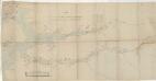
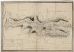
Kartblad 138: Vei-Cart over det Leirdalske Jæger Compagnie
Amund Wiegh
Spesielle kart 123-6: Kart over Drammensvassdraget
1 : 100000 Toralf à ̃yen
24A 10; 24A 11; 24C 2; 24C 3; 24C 6; 24C 7; 24C 8; 24C 10; 24C 11; 24C 12
1 : 100000 Bernt Lund
24C 12; 24C 8 (1/2); 24D 5 (1/2); 24D 9; 24D 10 (1/4); 30A 4; 30A 8 (3/4); 30A 12 (1/2); 30B 1; 30B 2 (1/2); 30B 5; 30B 6 (1/2); 30B 9; 30B 10; 30B 11
1 : 100000 Harald Nicolai Storm Wergeland
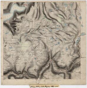
Museumskart 217-56: Specialkart over Sognefjorden
1 : 100000 G. Dellinger Den Geografiske Opmaaling
24C 12; 30A 4
1 : 100000
Kartblad 125: Carte over det Tiugumske Compagnie District

D31 vest Lærdal
1 : 100000