Maps of Grue
20D 4 sør
1 : 10000 Søren Hagerup Stabell | Ramm | Niels Stockfleth Darre
20D 4 sø
1 : 10000
20D 4 sv
1 : 10000
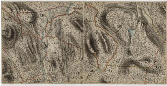
Trigonometrisk grunnlag, vedlegg 28: Fundament Mensul til Quadrat-Miilen No 114
1 : 10000 Johan Henrich Ramm | N. S. Darre
20D 4
1 : 50000 Daniel Tønnesen
Mil nr 123
1 : 10000 Johan Henrik Ramm
Mil nr 123
1 : 10000 Johan Henrik Ramm
2115-4 Svullrya
1 : 50000 Statens kartverk
2115-4 Lundersæter
1 : 50000 Norges Geografiske Oppmåling
2115-4 Lundersæter
1 : 50000 Norges Geografiske Oppmåling
2115-4 Lundersæter
1 : 50000 Statens kartverk
2115-4 Rævholt
1 : 50000 Norges Geografiske Oppmåling
2115-4 Lundersæter
1 : 50000 Statens kartverk
Trigonometrisk grunnlag, vedlegg 33: Fundament Mensul til Quadrat-Miilen No 123
1 : 10000 Johan Henrich Ramm | N. S. Darre
20B 12
1 : 50000 Daniel Tønnesen
Mil nr 124
1 : 10000 Johan Jacob Rieck (Rick)
20B 12 nv
1 : 10000 Johan Jacob Rieck
20D Søndre Solør
1 : 100000
20D Søndre Solør
1 : 100000 C. Pedersen | Arnt Magnus Andreassen Øgaard
20D Søndre Solør
1 : 100000 Arnt Magnus Andreassen Øgaard | H. Hagen
20D Søndre Solør
1 : 100000 Arnt Magnus Andreassen Øgaard | H. Hagen
20D Søndre Solør
1 : 100000 C. Pedersen | Arnt Magnus Andreassen Øgaard Brødr. Christiansen
20B Kongsvinger
1 : 100000 H. Hagen | Torgrim Lundtvedt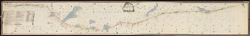
NRA GA 4
Friedenreich | Thodal | Ratkind | Holm | Marelius | Hejde
Kartblad 45: Wej-Cart over det Wingerske lette Infanterie Compagnies District

Portefølje nr 33
1 : 100000
Portefølje nr 33
1 : 100000
Kartblad 46: Wej-Cart over det Soleurske Compagnies District
Leegaard
Spesielle kart 20-2: Lillestrøm-Kongsvinger-Charlottenberg
1 : 400000 Albert Cammermeyer Forlag