Maps of Nes

20A-4
1 : 10000
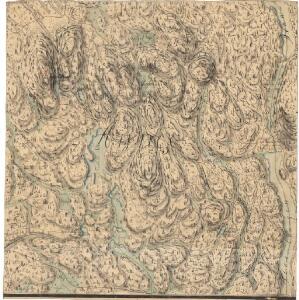
20A-4-nø
1 : 10000 Qvist
20A 4
1 : 20000 O. Lund
Mil nr 86
1 : 10000 O. von Gedde
20A-4-sø
1 : 10000 Qvist
20A-4-sv
1 : 10000 Qvist
20A-4-nv
1 : 10000 Qvist
Spesielle kart 50: Kart over Glommen eller Stor Elven fra Næss Kirke til Bingens Lentser; fløtningskart
Peter Hiort
20A-4-del
1 : 10000
Mil nr 76
1 : 10000 Stochfleth
20A 3 og 20A 4
1 : 10000 Qvist
15C 12 øst
1 : 10000 Stockfleth
Mil nr 86
1 : 10000 O. von Gedde
2015-3 Strøm
1 : 50000
2015-3 Ström
1 : 50000 Statens kartverk
Spesielle kart 104-1: Kart over Fredrikshaldsvassdraget med Mangenvassdraget
1 : 50000 Finn Qvale
Trigonometrisk grunnlag, vedlegg 22: Kvadratmilien No 97, kvadratmilen No 58
1 : 10000
20A Nannestad
1 : 100000 Johan Ferdinand Nordmann | Ole Engh
20A Nannestad
1 : 100000 Johan Ferdinand Normann | Carl Christian Olberg
20A Nannestad
1 : 100000 Johan Ferdinand Normann | Carl Christian Olberg
Kartblad 43: Wej-Cart over det Næsiske lette Infanterie Compagnies District

20A Nannestad
1 : 100000 Johan Ferdinand Normann | Carl Christian Olberg
20A Nannestad
1 : 100000 Carl Christian Olberg | Johan Ferdinand Normann
Geologiske kart 30: Den geologiske Undersøgelse, Nannestad
1 : 100000 T. Ch. Thomassen | Normann | Johan H. L. Vogt Norges geologiske undersøkelse
Trigonometrisk grunnlag, vedlegg 59
1 : 50000
Geologisk kart 10 Nannestad
1 : 100000
Trigonometrisk grunnlag, vedlegg 17: Fundament Mensul for Quadrat-Milen No 91
1 : 20000 Hans Nicolai Archtander | Niels Andreas Wibe
20B Kongsvinger
1 : 100000 H. Hagen | Torgrim Lundtvedt
Kart over iernbanelinie fra Christiania til à ̃ieren og Mjà ̧sen, tilligmed Vandlinien fra à ̃ieren til Mjà ̧sen
1 : 20000 Holcks Attelier