Maps of Lyngdal

1C 12; 4A 4
1 : 50000 Thorlak Aas
1C 11; 1C 12; 4A 3; 4A 4
1 : 50000 Andreas Dahl
1311-2 Farsund
1 : 50000 Statens kartverk
1D 9
1 : 50000 Thomas Georg Backer
1311-2 Farsund
1 : 50000 Norges Geografiske Oppmåling
1311-2 Farsund
1 : 50000 Norges Geografiske Oppmåling
Indseilingen til Sæløer, Korshavn, Ullerøsund, Lodshavn, Ekvaag og Farsund
1 : 20000 Schie Opmaalings Directionen
Museumskart 217-28: Innseilingskart til Flekkefjord, Egersund, Sogndalstranda m.fl.
1 : 20000 Schie Opmaalings Directionen
1311-2 Farsund
1 : 50000 Norges Geografiske Oppmåling
1311-2 Farsund
1 : 50000 Statens kartverk
1311-2 Farsund
1 : 50000 Statens kartverk
1411-3 Lyngdal
1 : 50000 Statens kartverk
1411-3 Lyngdal
1 : 50000 Norges Geografiske Oppmåling
Geologisk kart 3-1b: Snitt over det Søndenfjeldske Norge
1 : 200000 P. Waage | H. Mohn | Tellef Dahll | A. S. Bachke
1411-3 Lyngdal
1 : 50000 Statens kartverk
1411-3 Lyngdal
1 : 50000 Norges Geografiske Oppmåling
1411-3 Lyngdal
1 : 50000 Statens kartverk
1411-3 Lyngdal
1 : 50000 Norges Geografiske Oppmåling
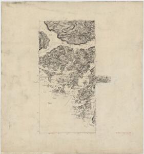
4B 1 4B 2
1 : 50000 F. Halle
Kartblad 160: Situations Carte den südwestlichen Theil des Capitain Arctanders Compagnie District
Loewenthael
1D 5; 1D 6; 1D 9; 1D 10
1 : 50000 Paul Hansen Birch Brun
1C 11; 4A 2; 4A 3
1 : 50000 Johan Ferdinand Normann
4B 1 4B 2 4B 5 4B 6
1 : 50000 Paul Hansen Birch Brun
Innseiling til Svinør
1 : 20000 Schie Opmaalings Directionen
4A 7
1 : 50000 Thomas Georg Backer
4B 5
1 : 50000 Thorleif Barlag
4A 8
1 : 50000 Thomas Georg Backer
Museumskart 217-2 Kart over Den Norske Kyst fra Christiansand til Ekersund
1 : 50000 H. Wille | Schie Opmaalings Directionen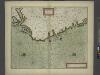
The coast of NORWAY from Bergen to the High Land of Horrel
from The sea-atlas : containing an hydrographical description of most of the sea-coasts of the known parts of the world.