Maps of Marker

15B 1
1 : 20000 Ramm
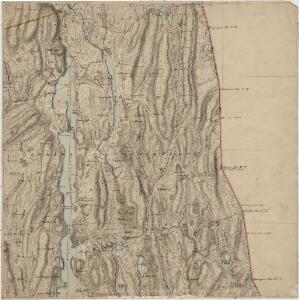
Jegerkorps nr 20-2: Kart over Aremark, Ødemark og Røddenæs
1 : 13330
H36-3 nordøst
1 : 20000 Andreas Theodor Walle | K. Lien | Lyder Selvik
Mil nr 37
1 : 10000 Carl Alexander Stricker
15B-1-vest
1 : 10000 Theodor Johann von Wegener
15B-1-øst
1 : 10000 Theodor Johann von Wegener
Mil nr 37
1 : 10000 Carl Alexander Stricker
Mil nr 30
1 : 10000
H36-3 sørøst
1 : 20000 Andreas Theodor Walle
10D-9-vest
1 : 10000 Theodor Johann von Wegener
H36-4 sørvest
1 : 20000 Andreas Theodor Walle
H36-3 nordvest
1 : 20000 K. Lien | Andreas Theodor Walle | Lyder Selvik
2013-4 Öymark
1 : 50000 Norges Geografiske Oppmåling
2013-4 Öymark
1 : 50000 Norges Geografiske Oppmåling
2013-4 Öymark
1 : 50000 Norges Geografiske Oppmåling
2013-4 Øymark
1 : 50000 Statens kartverk
2013-4 Øymark
1 : 50000 Statens kartverk
Kartblad 3- Vey-Kart over det Markerske Compagnie District; versjon 1
Rode
Spesielle kart 104-3: Kart over Fredrikshaldsvassdraget med Mangenvassdraget
1 : 50000 Finn Qvale
NRA GA 2
Ratkind | Thodal | Friedenreich | Bautz | Marelius | Holm
Kartblad 3-2: Vey-Kart over det Markerske Compagnie District; versjon 2
Rode
15B Øymark
1 : 100000
15B Øymark
1 : 100000 Johan Ferdinand Normann | C. Pedersen
15B Øymark
1 : 100000 Johan Ferdinand Normann | C. Pedersen
15B Øymark
1 : 100000 C. Pedersen | Johan Ferdinand Normann
15B Øymark
1 : 100000 Johan Ferdinand Normann | C. Pedersen
Jegerkorps nr 14: Kart over del av Rakkestad, Eidsberg og Rødenæs og en del av ødemarks anneks, øst
1 : 10000 von Staffeldt | P. H. Butenschiøn
Jegerkorps nr 16: Kart over Aremark og Rakkestad sogner med annekser, øst
1 : 10000 Myhre | von Staffeldt | P. H. Butenschiøn
10C 12
1 : 50000 Karl Fredrik Kase