Maps of Frogn

14D 4 sv
1 : 20000 Bull
14D 4 vest
1 : 10000 Hans Lemmich Juell
Mil nr 54
1 : 10000 Johan Henrich Ramm | Hans Lemmich Juell
14D 4
1 : 20000 Øverland
14D 4
1 : 40000 H. Hansen
14D 3 øst; 14D 4 vest
1 : 25000 Johannes Solem
14B 11 nø; 14B 12 nv; 14D 4 sv
1 : 25000 Johannes Solem
14B 12 nv
1 : 25000 Carl Axel Sigurd Sissener
1814-2 Drøbak
1 : 50000 Statens kartverk
1814-2 Dröbak
1 : 50000 Norges Geografiske Oppmåling
1814-2 Drøbak
1 : 50000 Statens kartverk
1814-2 Drøbak
1 : 50000 Statens kartverk
Mil nr 46
1 : 10000 Johan Henrich Ramm | Hans Lemmich Juell
Mil nr 46
1 : 10000 Johan Henrich Ramm | Hans Lemmich Juell
14D 3 sø
1 : 20000 Bull
14D 4 nv
1 : 20000 Bull
14D 4 nv del av sø/4
1 : 10000 Vilhelm Herman Ludvig von Munthe af Morgenstierne
14D 4 sv del av sø/4
1 : 10000 J. Ræder
Museumskart 217-43: Specialkart over Kristianiafjorden fra Kristiania til Drøbak
1 : 50000 H. N. Bergh | C. F. Wille Den Geografiske Opmaaling
1814-2 Dröbak
1 : 50000 Norges Geografiske Oppmåling
1814-2 Dröbak
1 : 50000 Norges Geografiske Oppmåling
Kartblad 29: Militært Cart over det Askerske Compagnie District
M. Grønvold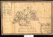
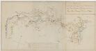
Kartblad 34: Militairt Cart over Nordrefollaugske Compagnie District
L. Rein | Petter Prydz
Museumskart 217-44: Specialkart over Kristianiafjorden fra Drammen og Drøbak til Bastø
1 : 50000 C. F. Wille | H. N. Bergh Den Geografiske Opmaaling
Kartblad 26-2: Det Huurumske Compagnie District; versjon 2
Kartblad 11-2: Wey-Cart over det Haabbelske Compagnie District, versjon 2

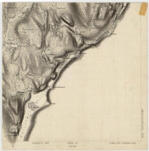
Geologisk kart 1 Den geologiske undersøgelse, Rektangel 14D Kristiania
1 : 100000 Kjerulf Norges geologiske undersøkelse
14D Oslo
1 : 100000 Johan Gulbrandsen Natrud | Ole Engh
14D Oslo
1 : 100000 E. Heiberg | H. N. Bergh