Maps of Nesodden

14D 12 sv
1 : 10000 Ditlev Vibe
14D 12 sv
1 : 10000 Ditlev Vibe
Kristiania amt nr 58: Detailkart over Christiania efter Kommunebestyrelsens Foranstaltning trigonometrisk og geometrisk opmaalt
1 : 1000 J. W. G. Næser
Kristiania amt nr 58: Detailkart over Christiania efter Kommunebestyrelsens Foranstaltning trigonometrisk og geometrisk opmaalt
1 : 1000 J. W. G. Næser
Kristiania amt nr 58: Detailkart over Christiania efter Kommunebestyrelsens Foranstaltning trigonometrisk og geometrisk opmaalt
1 : 1000 J. W. G. Næser
Kristiania amt nr 58: Detailkart over Christiania efter Kommunebestyrelsens Foranstaltning trigonometrisk og geometrisk opmaalt
1 : 1000 J. W. G. Næser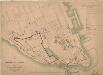
Kristiania amt nr 60: Kart over Agershus Fæstning med Plan til dens fremtidige Bebyggelse
1 : 2000 C. Schwenzens Lit. Officin
Kristiania amt nr 60: Kart over Agershus Fæstning med Plan til dens fremtidige Bebyggelse
1 : 2000 C. Schwenzens Lit. Officin
Kristiania amt nr 58: Detailkart over Christiania efter Kommunebestyrelsens Foranstaltning trigonometrisk og geometrisk opmaalt
1 : 1000 J. W. G. Næser
Kristiania amt nr 58: Detailkart over Christiania efter Kommunebestyrelsens Foranstaltning trigonometrisk og geometrisk opmaalt
1 : 1000 J. W. G. Næser
Geologiske kart Ladegaardsøens Jordbund. Snit over Wigwam og Oscarshal
1 : 25000 Kjerulf
Geologiske kart 28: Geologisk kart over Øerne ved Kristiania
1 : 10000 W. C. Brøgger
14D 8 nv
1 : 25000 Johannes Solem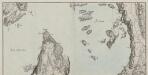
Mil nr 62
1 : 10000 Hans Lemmich Juell
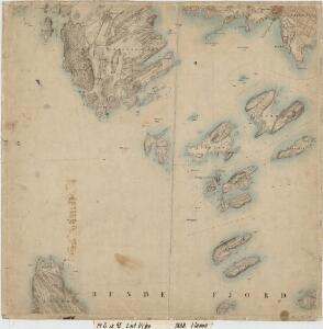
14D 12 sv
1 : 25000 Johannes Solem
14D 8 nø
1 : 25000 Johannes Solem
14D 12 sø
1 : 25000 Johannes Solem
Kristiania nr 82-1: Karta à ̧fver Staden Christiania i Norrige och Trakten der omkring
1 : 100000 O. J. Hagelstam
Kristiania nr 82b: Karta à ̧fver Staden Christiania i Norrige och Trakten der omkring
1 : 10000 O. J. Hagelstam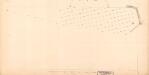
Grønlibryggen
1 : 1000 J. W. G. Næser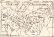
Gatorne i Christiania
1 : 50000 O. J. Hagelstam
14D 8
1 : 20000 Holmboe
14D 8
1 : 20000 W. Næser
Oslo blad 4
1 : 25000 NGO
14D 12 sv
1 : 25000
14D 12 nv
1 : 25000 Kristen Gran Gleditsch
Kristiania omegn blad 4
1 : 25000 J. Natrud | O. Engh NGO
Oslo omegn blad 2
1 : 25000 Solem | O. Engh NGO
Kristiania omegn blad 4
1 : 25000 J. Natrud | O. Engh NGO