Maps of Sande

14B 6
1 : 20000 Heyerdahl
14B 6 sør
1 : 25000 Nicolai Caspary Ræder | Marius Widerøe
14B 6 sør
1 : 25000 Nicolai Caspary Ræder | Marius Widerøe
14B 6 nø
1 : 25000 Christian Theodor Holtfodt
Holmestrand
1 : 20000 Gerhard Munthe | Pelecier | Malo | Niels Arentz Ramm
Holmestrand
1 : 2000 Krums Opmaaling
Holmestrand
1 : 100000
Holmestrand
1 : 2000 Krums Opmaaling
14B 6 nv; 14B 10 sv
1 : 25000 Karl A. Egeberg
14B 5 del, 14B 6 del, 14B 9 del, 14B 10 del
1 : 10000 Nils Stockfleth Darre Eckhoff | Hans Leopold Rustad | Hans Thomas Knoff | Wilhelm Krohn
14B 2 vest
1 : 50000 Kristen Gran Gleditsch
14B 1
1 : 50000 Carl Ludvig Soelberg
Museumskart 217-44: Specialkart over Kristianiafjorden fra Drammen og Drøbak til Bastø
1 : 50000 C. F. Wille | H. N. Bergh Den Geografiske Opmaaling
Kartblad 26- Det Huurumske Compagnie District; versjon 1

Kartblad 26-2: Det Huurumske Compagnie District; versjon 2

1814-3 Drammen
1 : 50000 Statens kartverk
14B Moss
1 : 100000
14B Moss
1 : 100000
14B Moss
1 : 100000
14B Moss
1 : 100000 H. N. Bergh | E. Heiberg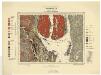
Geologiske kart 70: Norges geologiske undersøkelse. Kristianiafeltet-Moss
1 : 100000 W. C. Brøgger | Jakob Schetelig Norges geologiske undersøkelse
14B Moss
1 : 100000
14B Moss
1 : 100000
14B Moss
1 : 100000 E. Heiberg | H. N. Bergh
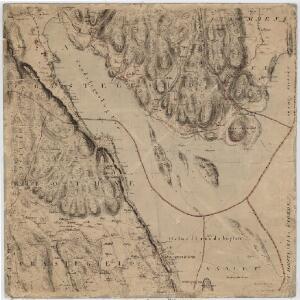
Kartblad 27: Kart over det Sandeske Compagnie District

1814-3 Drammen
1 : 50000 Statens kartverk
14B 1
1 : 50000 Marius Widerøe
1814-3 Drammen
1 : 50000 Statens kartverk
1814-3 Drammen
1 : 50000 Norges Geografiske Oppmåling