Maps of Oslo

Oslo omegn blad 4
1 : 25000 J. Natrud | O. Engh
Oslo omegn blad 4
1 : 25000 O. Engh | J. Natrud
Kristiania omegn blad 4
1 : 25000 J. Natrud | O. Engh NGO
Kristiania omegn blad 4
1 : 25000 J. Natrud | O. Engh NGO
Oslo blad 4
1 : 25000 NGO
15C 9 vest
1 : 25000 Johan Nicolai Hertzberg
Oslo omegn blad 4
1 : 25000 J. Natrud | O. Engh
Oslo blad 4
1 : 25000 NGO
14D 12 nø
1 : 25000 Finn Abrahamson
Trigonometrisk grunnlag, Squelet-Cart 62
Fra Oslo domkirke til Romsås
1 : 20000 J. H. Reichborn
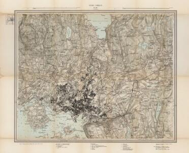
Geologiske kart 40: Geologisk kart over Kristiania by
1 : 15000 K. O. Bjørlykke Norges geologiske undersøkelse
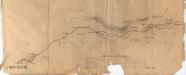
Kartblad I: Vei-kaart over den trondhjemske Kongevei fra Christiania til Røraas gjennom Eidsvold, Rommedal, Levthen og Østerdalen
1 : 20000 J. H. Reichborn
14D 12
1 : 20000 W. Næser
Spesielle kart 31: Oversigtskart over de mellem Christiania og Maridalen udstukne Linier.
1 : 25000
14D 12 sv
1 : 25000
Mil nr 72 (Christiania)
1 : 10000 Niels Stockfleth Darre
15C-9-vest
1 : 10000 Niels Stockfleth Darre | Friis
15C 9 vest
1 : 10000 Niels Stockfleth Darre | Friis
15C 6 vest
1 : 10000 Niels Stockfleth Darre | Friis
15C 9 nv
1 : 25000 Haakon Ditlef Lowzow | Johannes Solem
14D 12 sø
1 : 25000 Johannes Solem
15C 9 sv a
1 : 25000 Haakon Ditlef Lowzow | Johannes Solem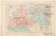
Kristiania
1 : 43000 Oslo (Norsko) F.A. Brockhaus' geogr.-artist. Anstalt
Oversiktskart over Kristiania amt nr 58
1 : 50000 J. W. G. Næser
Trigonometrisk grunnlag, Squelet-Cart 52: Trigonometrisk kart over Christiania og omegn
F. Næser
Kristiania nr 82-1: Karta à ̧fver Staden Christiania i Norrige och Trakten der omkring
1 : 100000 O. J. Hagelstam
15C 9 sv b
1 : 25000 Johannes Solem | Haakon Ditlef Lowzow
14D 12 nv
1 : 10000 W. Næser