Maps of Løten

Fra Grundset til Johannesstua
1 : 20000 J. H. Reichborn
Kartblad VI: Vei-kaart over den trondhjemske Kongevei fra Christiania til Røraas gjennom Eidsvold, Rommedal, Levthen og Østerdalen
1 : 20000 J. H. Reichborn
26C 4 vest
1 : 10000
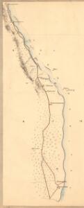
Mil nr 183
1 : 10000 Johan Henrich Ramm | Eilert Woldemar Preben Ramm
26C 4
1 : 50000 Johannes Solem
26C 4
1 : 50000 Johannes Solem
Mil nr 183
1 : 10000 Johan Henrich Ramm | Eilert Woldemar Preben Ramm
26C 4 øst
1 : 10000
Kartblad 49b: Geographisk Charte over Conturen af det Leuthenske mig Allernaadigst anbetroede Compagnie
Rick
2016-4 Elverum
1 : 50000 Norges Geografiske Oppmåling
H32-7; H32-8
1 : 50000 Kaare Kvisgaard
26C Åmot
1 : 100000 C. Pedersen | Arnt Magnus Andreassen Øgaard
26C Åmot
1 : 100000 Arnt Magnus Andreassen Øgaard | C. Pedersen
26C Åmot
1 : 100000 Nicolai Franck | Arnt Magnus Andreassen Øgaard
26C Åmot
1 : 100000 C. Pedersen | Arnt Magnus Andreassen Øgaard
26C Åmot
1 : 100000 C. Pedersen | Arnt Magnus Andreassen Øgaard
H32-7; H32-8
1 : 50000 Kaare Kvisgaard
1916-1 Löten
1 : 50000 Norges Geografiske Oppmåling
1917-2 Rena
1 : 50000 Statens kartverk
2017-3 Julussa
1 : 50000 Norges Geografiske Oppmåling
Ekserserplasskart; Terningmoen med omgivelser
1 : 50000
2016-4 Elverum
1 : 50000 Norges Geografiske Oppmåling
2016-4 Elverum
1 : 50000 Statens kartverk
2016-4 Elverum
1 : 50000 Statens kartverk
2016-4 Elverum
1 : 50000 Norges Geografiske Oppmåling
2016-4 Elverum
1 : 50000 Statens kartverk
1916-1 Löten
1 : 50000 Statens kartverk
1916-1 Løten
1 : 50000 Statens kartverk
Ekserserplasskart; Terningmoen med omgivelser
1 : 50000