Maps of Eidsvoll

Fra Strandlykkja til Hestnes
1 : 20000 J. H. Reichborn
20C 11 b
1 : 50000 Frithjof Jacobsen
20C 11
1 : 20000
20C 11 a
1 : 50000 Frithjof Jacobsen
1916-2 Tangen
1 : 50000 Statens kartverk
1916-2 Tangen
1 : 50000 Norges Geografiske Oppmåling
1916-2 Tangen
1 : 50000 Statens kartverk
1916-2 Tangen
1 : 50000 Statens kartverk
1916-2 Tangen
1 : 50000 Norges Geografiske Oppmåling
Kartblad IV: Vei-kaart over den trondhjemske Kongevei fra Christiania til Røraas gjennom Eidsvold, Rommedal, Levthen og Østerdalen
1 : 20000 J. H. Reichborn
1916-2 Tangen
1 : 50000 Norges Geografiske Oppmåling
Kartblad 48: Militair Cart over det Stangeske Compagnie District
Falck
20C Eidsvoll
1 : 100000 Gjestvang | Torgrim Lundtvedt
20C Eidsvoll
1 : 100000 H. C. Wanggård | Torgrim Lundtvedt | Gjestvang
20C Eidsvoll
1 : 100000 Gjestvang | Torgrim Lundtvedt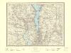
20C Eidsvoll
1 : 100000
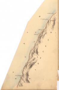
Kartblad 4 Cituations-Cart over det Edsvoldske Compagnies Distrigt
Neumann
Kartblad 49: Militairisk Cart over det Leuthenske Compagnie District
Jens Jacobsen Jentoft
20C Eidsvoll
1 : 100000 Torgrim Lundtvedt | Gjestvang | H. C. Wanggård
20C Eidsvoll
1 : 100000 Gjestvang | Torgrim Lundtvedt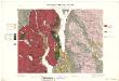
Geologisk kart 33: Den Geologiske Undersøgelse, Rektangel 20C Eidsvold
1 : 100000 Torgrim Lundtvedt | Gjestvang Norges geologiske undersøkelse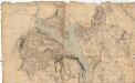
Norge 125: Kart over Toten; Næs og Stange Præstgjæld
1 : 72000
Portefølje nr 32
1 : 100000 F. Akrell
20C Eidsvoll
1 : 100000 Torgrim Lundtvedt | Gjestvang
5428 Hamar
1 : 100000
20C Eidsvoll
1 : 100000 Gjestvang | Torgrim Lundtvedt
Portefølje nr 32
1 : 100000
Portefølje nr 32
1 : 100000
Spesielle kart 22-5: Minnesund - Elverum
1 : 400000 Albert Cammermeyer Forlag