Maps of Holtålen

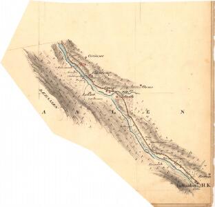
Fra Gronset til Holtålen
1 : 20000 J. H. Reichborn
Fra Almås til Gillset
1 : 20000 J. H. Reichborn
1620-1 Haltdalen
1 : 50000 Statens kartverk
1620-1 Haltdalen
1 : 50000 Norges Geografiske Oppmåling
1620-1 Haltdalen
1 : 50000 Norges Geografiske Oppmåling
43C 5; 43C 6; 43C 9; 43C 10
1 : 50000 Johan Lauritz Bull
1620-1 Haltdalen
1 : 50000 Statens kartverk
1620-1 Haltdalen
1 : 50000 Statens kartverk
43C Holtaalen
1 : 100000 Johan Gulbrandsen Natrud | H. Hagen
43C Holtaalen
1 : 100000 Ole Engh | Johan Gulbrandsen Natrud
43C Haltdalen
1 : 100000
43C Haltdalen
1 : 100000 Johan Gulbrandsen Natrud | Ole Engh
43C Holtaalen
1 : 100000 Johan Gulbrandsen Natrud | H. Hagen
43C Haltdalen
1 : 100000
43C Haltdalen
1 : 100000 Johan Gulbrandsen Natrud | Ole Engh
Portefølje nr 71
1 : 100000 Munthe
Portefølje nr 71
1 : 100000 Munthe
Kartblad 93: Carte over det Selboische Compagnie District
Carl Henning Krog
Spesielle kart 22-2: Tyvold - Rognæs
1 : 400000 Albert Cammermeyer Forlag
Spesielle kart 103-1: Flötningskart over Glommens Vassdrag
1 : 1000 Einar Sigurd Ween
Norge 55-6: Accurat landcaart over Norges Rige anden Part
1 : 300000 G. Bordin
Røros
1 : 250000
Geologisk kart 92: Kvartærgeologisk kart, Røros
1 : 250000 Gunnar Holmsen Norges geologiske undersøkelse
Trigonometrisk grunnlag, Squelet-Cart 65-14

Røros
1 : 250000
Trondheim
1 : 250000
Statistikk _43-14-2: Bosettingskart over Røros. Blad 14.
1 : 250000
Spesielle kart: Tyngdeanomalikart, RÃ ̧ros
1 : 250000 NGO
Norge 55-10: Accurat landcaart over Norges Rige anden Part
1 : 300000 G. Bordin