Maps of Oppdal

Fra Lo til Oppdal kirke
1 : 20000 J. H. Reichborn
Kartblad nr 12 og 5: Kaart over Postveien fra Korsødegaarden til Trondhjem igjennom Gulbrandsdalen over Dovrefjeld
1 : 20000 J. H. Reichborn
42A 8; 42A 12; 42B 5; 42B 9
1 : 50000 Johan Lauritz Bull
1520-3 Oppdal
1 : 50000 Norges Geografiske Oppmåling
1520-3 Oppdal
1 : 50000 Statens kartverk
1520-3 Oppdal
1 : 50000 Norges Geografiske Oppmåling
42A 7
1 : 50000
1520-3 Oppdal
1 : 50000 Statens kartverk
42A 11
1 : 50000 Thorlak Aas
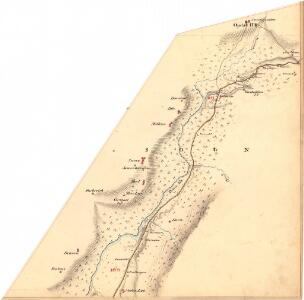
Kartblad 13 Rids af det Opdalske Compagnie District
Johan Hammond
fra Vollen til Risan
1 : 20000 J. H. Reichborn
Fra Bjørndal til Dånnåliplassen
1 : 20000 J. H. Reichborn
42A Opdal
1 : 100000 Johan Nordhagen | F. Jacobsen
42A Oppdal
1 : 100000
42A Oppdal
1 : 100000
42A Opdal
1 : 100000 F. Jacobsen | Ole Engh
42A Oppdal
1 : 100000
42A Opdal
1 : 100000 Ole Engh | F. Jacobsen
42A Opdal
1 : 100000 Ole Engh | F. Jacobsen
42A Opdal
1 : 100000 Ole Engh | F. Jacobsen
42A Opdal
1 : 100000 F. Jacobsen | Ole Engh
Kartblad 11 Vei Kort igienem det Sundalske Compagnie District

Kartblad 110: Carte over det Opdalske Compagnie District
M. F. Dons
Spesielle kart 111-2: Oversigtskart til Kaptejn J. Sejersted's Indberetning angaaende Grænsen mellem Trondhjem's og Hamar's Stifter
1 : 100000 J. Sejersted
Kartblad 104: Carte over det Størensche Compagnie District
A. Collin
Spesielle kart 113-2: Oversigtskart over de forskjellige Grænsealternativer mellem Trondhjems Stift og Hamar og Bergens Stifter
1 : 100000 J. Sejersted
Kartblad 166b-1a: Wej-Cart over det Aamodske Compagnie; 166b-1a

[Romsdals Amt]
1 : 200000 Norsko Norges geografiske Opmaling
Trigonometrisk grunnlag, Squelet-Cart 65-13