Maps of Rennebu
Fra Bjørndal til Dånnåliplassen
1 : 20000 J. H. Reichborn
Kartblad 13 Rids af det Opdalske Compagnie District
Johan Hammond
42A 8; 42A 12; 42B 5; 42B 9
1 : 50000 Johan Lauritz Bull
42C 3; 42C 4
1 : 50000 Thorlak Aas
1520-2 Innset
1 : 50000 Statens kartverk
1520-2 Innset
1 : 50000 Norges Geografiske Oppmåling
1520-2 Innset
1 : 50000 Norges Geografiske Oppmåling
1520-2 Innset
1 : 50000 Statens kartverk
Kartblad nr 12 og 5: Kaart over Postveien fra Korsødegaarden til Trondhjem igjennom Gulbrandsdalen over Dovrefjeld
1 : 20000 J. H. Reichborn
Fra Lo til Oppdal kirke
1 : 20000 J. H. Reichborn
Kartblad nr 13 og 4: Kaart over Postveien fra Korsødegaarden til Trondhjem igjennom Gulbrandsdalen over Dovrefjeld
1 : 20000 J. H. Reichborn
Fra Fagerhaugen til Langklopp
1 : 20000 J. H. Reichborn
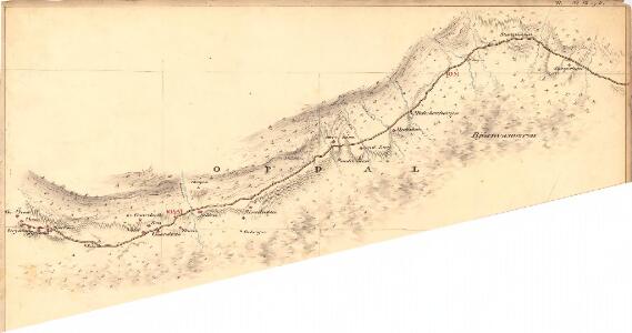
Kartblad 110: Carte over det Opdalske Compagnie District
M. F. Dons
Spesielle kart 111-2: Oversigtskart til Kaptejn J. Sejersted's Indberetning angaaende Grænsen mellem Trondhjem's og Hamar's Stifter
1 : 100000 J. Sejersted
Kartblad 104: Carte over det Størensche Compagnie District
A. Collin
Spesielle kart 113-2: Oversigtskart over de forskjellige Grænsealternativer mellem Trondhjems Stift og Hamar og Bergens Stifter
1 : 100000 J. Sejersted
Kartblad 166b-1a: Wej-Cart over det Aamodske Compagnie; 166b-1a

[Romsdals Amt]
1 : 200000 Norsko Norges geografiske Opmaling
Trigonometrisk grunnlag, Squelet-Cart 65-13

Norge 55-14: Accurat landcaart over Norges Rige anden Part
1 : 3000000 G. Bordin
Geologisk kart over det Söndenfjeldske Norge
1 : 400000 Nordwest-Blatt Kjerulf, Theodor ; Dahll, Tellef Carl Schwenzens
Statistikk _43-14-2: Bosettingskart over Røros. Blad 14.
1 : 250000
Spesielle kart: Tyngdeanomalikart, RÃ ̧ros
1 : 250000 NGO
Norge 55-10: Accurat landcaart over Norges Rige anden Part
1 : 300000 G. Bordin
Bl. XI Molde
1 : 300000
Kartblad 107: Situations Cart over det 2det Trondhiemske Regiments District
J. C. R.
XI
1 : 400000 N. Franck
Statistikk 43-14-1: Bosettingskart over Røros. Blad14
1 : 250000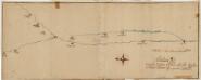
Kartblad 166: Situations Cart over det nordre Østerdahlske Herr Capitaine Blixes Skiløber Compagnies District