Maps of Lindås

Portefølje nr 34
1 : 100000 E. Lund
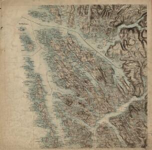
Museumskart 89:Speciel Kaart over en Deel af Den Norske Kyst, Bergen og Fedje
1 : 70000 Carl Frederik Grove
Museumskart 90: Speciel Kaart over en Deel af Den Norske Kyst
1 : 50000 Carl Frederik Grove
Museumskart 217-62: Specialkart over Den Norske Kyst fra Blomø til Ronglevær
1 : 50000 G. Dellinger Den Geografiske Opmaaling
A31 aust Fensfjorden
1 : 100000
22B Haus
1 : 100000 H. T. Bjørnstad | H. Hagen | F. Eriksen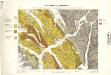
Geologiske kart 17: Den geologiske Undersøgelse, Haus
1 : 100000 H. T. Bjørnstad | Th. Hjortdahl | M. Irgens Norges geologiske undersøkelse
1116-3 Herdla
1 : 50000 Statens kartverk
22B Haus
1 : 100000 H. T. Bjørnstad | Ellef Nilsen | F. Eriksen
22B Haus
1 : 100000 H. T. Bjørnstad | F. Eriksen
1116-2 Sæbö
1 : 50000 Statens kartverk
22B Haus
1 : 100000 H. T. Bjørnstad | F. Eriksen
22B Haus
1 : 100000 H. T. Bjørnstad | H. Hagen | F. Eriksen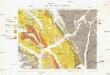
Haus
1 : 100000 Norsko Geologiske undersogelse
A33 aust Herdla
1 : 100000
A33 aust Herdla
1 : 100000
A33 aust Herdla
1 : 100000
22A Herlø
1 : 100000 H. T. Bjørnstad | E. Heiberg
22A Herlø
1 : 100000 H. T. Bjørnstad | Einar Sigurd Ween
A33-10; A33-11
1 : 50000 A. Bleken
1116-2 Saebö
1 : 50000 Norges Geografiske Oppmåling
1116-3 Herdla
1 : 50000 Statens kartverk
1116-3 Herdla
1 : 50000 Norges Geografiske Oppmåling
1116-2 Sæbø
1 : 50000 Statens kartverk
1116-2 Knarvik
1 : 50000 Statens kartverk
B33-7
1 : 50000 Adler Gleditsch
1116-3 Herdla
1 : 50000 Norges Geografiske Oppmåling
A32-5; A32-6
1 : 50000 Adler Gleditsch | Gustav Adolf Tajet
1116-2 Sæbö
1 : 50000 Norges Geografiske Oppmåling