Maps of Nesset

Maps of Nesset

$title$

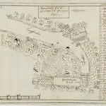
Kartblad 117: Topographisk Wej-Cart over det Eritsfiordske Compagnie District

$title$

Kartblad 116: Carte over det Nordre Romsdahlske eller det Eridsfiordske Compagnie District

Johan Christian Richelieu
$title$

Kartblad 115: Carte over det Fanneøttingske Compagnie District

Carl Køppen | Elias Heltberg Darre
$title$

Kartblad 113: Cart over det Romsdahlske Compagnie District

Johan A. Throne
$title$

Kartblad 118: Vei-Kort over det Gangnatiske Compagnie District

Elias Nægler
$title$

1320-3 Åndalsnes

1 : 50000 Statens kartverk
$title$

1320-2 Eresfjord

1 : 50000 Statens kartverk
$title$

41B 9; 41B 10; 41D 1; 41D 2

1 : 50000
$title$

41A 5; 41A 6; 41A 9; 41A 10

1 : 50000 Frithjof Jakobsen
$title$

1320-3 Åndalsnes

1 : 50000 Statens kartverk
$title$

1320-2 Eresfjord

1 : 50000 Statens kartverk
$title$

1320-3 Åndalsnes

1 : 50000 Norges Geografiske Oppmåling
$title$

1320-2 Eresfjord

1 : 50000 Norges Geografiske Oppmåling
$title$

Ekserserplasskart; Kroki over Setnesmoen med omgivelser

1 : 50000
$title$

41C 6; 41C 7; 41C 10; 41C 11

1 : 50000 Christoffer Fredrik von Lowzow
$title$

1320-4 Eide

1 : 50000 Statens kartverk
$title$

41C 8; 41C 12; 41D 5; 41D 9

1 : 50000
$title$

1320-1 Tingvoll

1 : 50000 Statens kartverk
$title$

1320-1 Tingvoll

1 : 50000 Norges Geografiske Oppmåling
$title$

1320-1 Tingvoll

1 : 50000 Statens kartverk
$title$

1320-4 Eide

1 : 50000 Norges Geografiske Oppmåling
$title$

1320-4 Eide

1 : 50000 Statens kartverk
$title$

41C 2; 41C 3

1 : 50000 Christian Due
$title$

41B 5; 41B 6

1 : 50000
$title$

41A 3; 41A 4; 41A 7; 41A 8

1 : 50000 Christian Due
$title$

1420-3 Sunndalsøra

1 : 50000 Statens kartverk
$title$

1420-3 Sunndalsöra

1 : 50000 Statens kartverk
$title$

1420-3 Sunndalsöra

1 : 50000 Norges Geografiske Oppmåling
$title$

Kartblad 121-2: Vei Kort over det Giemniske Compagnie District; versjon 2 (+ informasjon 2b)

Christian Nicolai Dagenboldt
$title$

41C 5; 41C 9

1 : 50000 Eiler Christian Holtermann
© MapTiler © OpenStreetMap contributors
How does it work?
These instructions will show you how to find historical maps online.
Getting started
Type the place name in the search box to find the exact location. You can further adjust the search by zooming in and out.
Zoom
Zoom in and out with the buttons or use your mouse or touchpad natively.
Exact Area tool
Click here and draw a rectangle over the map to precisely define the search area.
Set filters
Narrow your search with advanced settings, such as Years (from/to), Fulltext, Publisher, etc.
Results
See the results of your search on the right side. You can scroll down to find more maps of this location.
?

Download OldMapsOnline Mobile