Maps of Nesset

Kartblad 116: Carte over det Nordre Romsdahlske eller det Eridsfiordske Compagnie District
Johan Christian Richelieu
Kartblad 117: Topographisk Wej-Cart over det Eritsfiordske Compagnie District
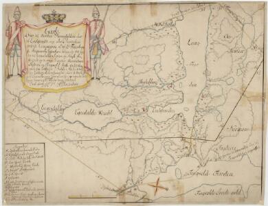
Kartblad 113: Cart over det Romsdahlske Compagnie District
Johan A. Throne
Kart i 100000 over nedslagsfeltene for Aura; Lilledalselven og Mardøla
1 : 100000 Marius Widerøe
Kartblad 115: Carte over det Fanneøttingske Compagnie District
Carl Køppen | Elias Heltberg Darre
Kartblad 11 Vei Kort igienem det Sundalske Compagnie District

Kart i 100000 over nedslagsfeltene for Aura; Lilledalselven og Mardøla
1 : 100000 Finn Qvale | Marius Widerøe
1420-3 Sunndalsöra
1 : 50000 Statens kartverk
1320-2 Eresfjord
1 : 50000 Statens kartverk
1420-3 Sunndalsöra
1 : 50000 Norges Geografiske Oppmåling
1420-3 Sunndalsøra
1 : 50000 Statens kartverk
41B 9; 41B 10; 41D 1; 41D 2
1 : 50000
41D 3; 41D 4
1 : 50000 Frithjof Jacobsen
41B 3; 41B 7
1 : 50000
41B 8; 41B 11; 41B 12
1 : 50000 Wilhelm Sørensen
1420-3 Sunndalsøra
1 : 50000 Statens kartverk
1420-3 Sunndalsöra
1 : 50000 Statens kartverk
1320-2 Eresfjord
1 : 50000 Statens kartverk
1320-2 Eresfjord
1 : 50000 Norges Geografiske Oppmåling
Ekserserplasskart; Kroki over Setnesmoen med omgivelser
1 : 50000
41B 5; 41B 6
1 : 50000
1320-3 Åndalsnes
1 : 50000 Statens kartverk
41A 3; 41A 4; 41A 7; 41A 8
1 : 50000 Christian Due
1320-3 Åndalsnes
1 : 50000 Norges Geografiske Oppmåling
1320-3 Åndalsnes
1 : 50000 Statens kartverk
41C 2; 41C 3
1 : 50000 Christian Due
1420-4 Stangvik
1 : 50000 Statens kartverk
41C 6; 41C 7; 41C 10; 41C 11
1 : 50000 Christoffer Fredrik von Lowzow
1320-1 Tingvoll
1 : 50000 Statens kartverk