Maps of Aust-Agder

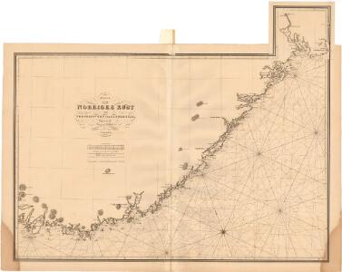
Museumskart 63: Karta öfver Norriges Kust från Fredriksvärn till Lindesnäs
1 : 150000 Gustaf Klint
II
1 : 400000 L. Arentz
II
1 : 400000 L. Arentz
Statistikk 43-2-2: Bosettingskart over Arendal. Blad 2
1 : 250000 Statistisk Sentralbyrå
Trigonometrisk grunnlag, Squelet-Cart 65-1
Trigonometrisk grunnlag, Squelet-Cart 18- Kysten fra Tromøy til Christiansand
Niels Andreas Wibe | B. Aubert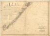
Museumskart 56: Kart over Den Norske Kyst fra Jomfruland og Kragerø til Christiansand
1 : 200000 H. Wille | Schie | C. Diriks
Geologiske kart 121-V2: Kart med magnetisk totalfelt. Arendal
1 : 250000 Norges geologiske undersøkelse
Museumskart 217-20: Kart over Den Norske Kyst fra Jomfruland og Kragerø til Christiansand
1 : 50000 Schie | C. Diriks | H. Wille Opmaalings Directionen
Trigonometrisk grunnlag, Squelet-Cart 45: Kart for 1849
F. Næser
Trigonometrisk grunnlag, Squelet-Cart 46: Kart for 1850
C. Bassøe
Statistikk 43-2- Bosettingskart over Arendal. Blad 1
1 : 250000 Statistisk Sentralbyrå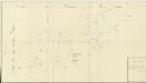
Trigonometrisk grunnlag, Squelet-Cart 18-2: Kysten fra Tromøy til Christiansand
Niels Andreas Wibe | B. Aubert
Kart over Lister og Mandals amt
1 : 200000 Norsko Gjessing, Soren Christian Geografiske opmaaling
Geologiske kart 121-F: Kart med magnetisk totalfelt. Mandal
1 : 250000 Norges geologiske undersøkelse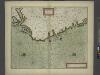
The coast of NORWAY from Bergen to the High Land of Horrel
from The sea-atlas : containing an hydrographical description of most of the sea-coasts of the known parts of the world.
Trigonometrisk grunnlag, Squelet-Cart 42: Kart over de i sommeren 1847 av Lieut: F. Næser trigonometrisk bestemte punkter
F. Næser
Trigonometrisk grunnlag, Squelet-Cart 19-2: Kysten fra Kragerø til Tromøy
Niels Andreas Wibe | B. Aubert
Trigonometrisk grunnlag, Squelet-Cart 19- Kysten fra Kragerø til Tromøy
B. Aubert | Niels Andreas Wibe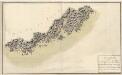
Museumskart 76: Speciel Kaart over en Deel af Den Norske SøeKyst
1 : 50000 Carl Frederik Grove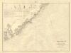
Museumskart 217-24: Kart over Den Norske Kyst fra Arendal til Christiansand
1 : 50000 H. Wille | C. Diriks | Vibe Opmaalings Directionen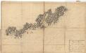
Museumskart 75: Speciel Kaart over en Deel af Den Norske SøeKyst
1 : 50000 Carl Frederik Grove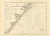
Museumskart 217-23: Kart over Den Norske Kyst fra Jomfruland og Kragerø til Arendal
1 : 50000 Fehr | Vibe | C. Diriks Opmaalings Directionen
Museumskart 60c: Kart over strekningen Kristiansand-Risør
1 : 200000 Rasmus Iuel
Portefølje nr 6
1 : 100000
Portefølje nr 7
1 : 100000 G. A. Sommerfeldt
Portefølje nr 2
1 : 100000 H. Gill
Portefølje nr 7
1 : 100000 G. A. Sommerfeldt
Portefølje nr 8
1 : 100000 H. Gill