Maps of Værøy
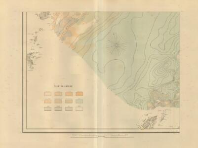
Museumskart 217-49: Fiskekart over den indre del af Vestfjorden i Lofoten
1 : 100000 M. Lyng Den Geografiske Opmaaling
J12 Helligvær
1 : 100000 Carl Christian Olberg | Torgrim Lundtvedt
J12 Helligvær
1 : 100000 Carl Christian Olberg | Torgrim Lundtvedt
J12 Helligvær
1 : 100000 Torgrim Lundtvedt | Carl Christian Olberg
J12 Helligvær
1 : 100000
I11-sør, I12-nord
1 : 50000 Haakon Schive | Carl Peter Bruun
J12 sørøstre del
1 : 50000 Marius Widerøe
I11 Lofotodden
1 : 100000
1830-3 Væröy
1 : 50000 Statens kartverk
1830-3 Væröy
1 : 50000 Norges Geografiske Oppmåling
1929-1 Helligvær
1 : 50000 Norges Geografiske Oppmåling
1830-3 Væröy
1 : 50000 Statens kartverk
1830-3 Værøy
1 : 50000 Statens kartverk
1929-4 Tenholmene
1 : 50000 Norges Geografiske Oppmåling
1929-1 Helligvær
1 : 50000 Norges Geografiske Oppmåling
1929-1 Helligvær
1 : 50000 Statens kartverk
1929-4 Tennholman
1 : 50000 Statens kartverk
I11 Lofotodden
1 : 100000
I11 Lofotodden
1 : 100000 Johan Gulbrandsen Natrud | C. Pedersen
I11 Lofotodden
1 : 100000 Johan Gulbrandsen Natrud | H. C. Wanggård
I11 Lofotodden
1 : 100000 Johan Gulbrandsen Natrud | H. C. Wanggård
I11 Lofotodden
1 : 100000 Johan Gulbrandsen Natrud | H. C. Wanggård
I11 Lofotodden
1 : 100000 Johan Gulbrandsen Natrud | C. Pedersen
1830-1 Lofotodden
1 : 50000 Statens kartverk
1929-4 Tennholman
1 : 50000 Statens kartverk
1929-4 Tennholman
1 : 50000 Norges Geografiske Oppmåling
1929-1 Helligvær
1 : 50000 Statens kartverk
1830-1 Lofotodden
1 : 50000 Norges Geografiske Oppmåling
1830-1 Lofotodden
1 : 50000 Statens kartverk