Maps of Sokndal

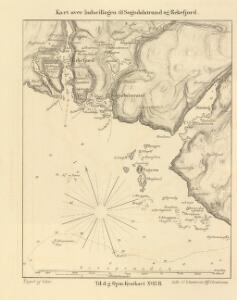
Indseilingen til Sogndalstrand og Rekefjord
1 : 20000 Schie Opmaalings Directionen
4A 9 4A 10 (1/3)
1 : 50000 Ivar Lund
1311-4 Sokndal
1 : 50000 Statens kartverk
1311-4 Sokndal
1 : 50000 Norges Geografiske Oppmåling
1311-4 Sokndal
1 : 50000 Statens kartverk
1311-4 Sokndal
1 : 50000 Norges Geografiske Oppmåling
1311-4 Sokndal
1 : 50000 Norges Geografiske Oppmåling
4A 9 4A 10 4C 1 4C 2
1 : 50000
C39-1; C39-2; C39-3
A. H.
3B 12
1 : 50000 David Vogt
4A Flekkefjord
1 : 100000
4A Flekkefjord
1 : 100000 Torgrim Lundtvedt | C. Pedersen
4A Flekkefjord
1 : 100000 C. Pedersen | Torgrim Lundtvedt
4A Flekkefjord
1 : 100000
4A Flekkefjord
1 : 100000 Torgrim Lundtvedt | C. Pedersen
Portefølje nr 1
1 : 100000 F. Næser | H. Gill
Portefølje nr 1
1 : 100000 F. Næser | H. Gill
Museumskart 66: Kart over den Norske kyst fra Lindesnæs til Ekersund
1 : 100000 H. Wille | Schie
Museumskart 72: Kyststrekningen fra Sireåen til Tungenes
1 : 20000 Rasmus Iuel
Spesielle kart 36: Egersund - Flekkefjordbanen
1 : 200000
Museumskart 217-27: Kart over Den Norske Kyst fra Lindesnæs til Ekersund
1 : 50000 H. Wille | Schie Opmaalings Directionen
Spesielle kart 13: Kart over den projekterede Jernbanelinie mellem Stavanger og Ekersund
1 : 200000
Kartblad 15 Situations Cart over det 1ste Stavangerske Compagnie District
C. Tobiesen
Museumskart 217-2 Kart over Den Norske Kyst fra Christiansand til Ekersund
1 : 50000 H. Wille | Schie Opmaalings Directionen
Trigonometrisk grunnlag, Squelet-Cart 47: Kart for 1851
C. S. Grimsgaard
Geologiske kart 121-F: Kart med magnetisk totalfelt. Mandal
1 : 250000 Norges geologiske undersøkelse
Museumskart 68: Kart over den Norske kyst fra Christiansand til Ekersund
1 : 200000 H. Wille | Schie
Statistikk 43-1-2: Bosettingskart over Mandal. Blad 1
1 : 250000 Statistisk Sentralbyrå
Statistikk 43-1- Bosettingskart over Mandal. Blad 1
1 : 250000 Statistisk Sentralbyrå