Maps of Scandinavia

Museumskart 46: Kart over Østersjøen
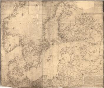
1 : 500000 Jens Sørensen
Kaart van de Oost-Zee met hare golven, baaijen, eilanden, rotsen, klippen, diepten, enz. enz. benevens den platten grond op groote schaal van de voornaamste zee-plaatsen krijgs- en handelhavens
1 : 2584000 uit de naauwkeurigste bronnen geput en uit de beste zee- en landkaarten opgemaakt door A.J. Bogaerts lithograaph Breda : Bogaerts
Schweden. Größte Machtentfaltung (1658)
1 : 18000000 Ostseeraum, Schweden, Expansion
Schweden. Größte Machtentfaltung (1658)
1 : 15000000 Ostseeraum, Schweden
Scandinavia.
1 : 4800000 Lizars, Daniel
Composite: Courones du nord.
1 : 2500000 L'Isle, Guillaume de, 1675-1726
Denmark, Sweden, Norway.
1 : 7900000 Tanner, Henry S.
[Neuer Atlas der ganzen Erde nach den neuesten Bestimmungen ... : XII.] Schweden, Norwegen und Daenemark
Nach den besten Materialien entworfen von F.W. Streit Leipzig : J.C. Hinrichssche Buchhandlung
Nordeuropa 1867
Nordeuropa Kunz, Andreas ; Röss, Wolf ; Johnen, Bettina ; Moeschl, Joachim Robert
Nordeuropa 1991
Nordeuropa Kunz, Andreas ; Treiling, Thomas
Courones du Nord (sud)
1 : 2600000 L'Isle, Guillaume de, 1675-1726
Schweden, Norwegen und Dänemark
Schul-Atlas über alle Theile der Erde nach dem neuesten Zustande, und über das Weltgebäude Stieler, Adolf Justus Perthes
Schweden und Norwegen
E. von Sydow's Schul-Atlas in sechs und dreissig Karten Sydow, Emil von bei Justus Perthes
Suede, Norvege, Danemark.
1 : 4500000 Brue, Adrien Hubert, 1786-1832
Chart of the Baltic.
Hughes, William
Suede, Norvege, et Danemark.
1 : 5900000 Monin, C.V.
Territoriale Erwerbungen Schwedens 1561-1658
Schweden Expansion
Ice Chart, Baltic Sea, October.
U.S. Navy
Scandinavien
Neuer Handatlas über alle Theile der Erde Kiepert, Heinrich Verlag von Dietrich Reimer
Schweden, Norwegen und Dänemark
Schul-Atlas über alle Theile der Erde nach dem neuesten Zustande, und über das Weltgebäude Stieler, Adolf bei Justus Perthes

Scandinavien bis zur calmarischen Union, 1397.
1 : 6000000 Spruner von Merz, Karl
Scandia, Scandinavia.
1 : 3050000 Faden, William, 1750?-1836
Ice Chart, Baltic Sea, April.
U.S. Navy
Ice Chart, Baltic Sea, March.
U.S. Navy
Statistikk 42: Døgnets normaltemperatur i Skandinavia, april måned
1 : 4000000
The Baltic Sea.
Mitchell, Samuel Augustus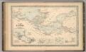
The Baltic Sea.
Mitchell, Samuel Augustus
Nordeuropa 2003
Nordeuropa Kunz, Andreas ; Treiling, Thomas