Maps of Halden
Mil nr 3
1 : 10000
Norge 266: Croquis Over Positionerne under Affæiren ved Bærbye den 12te September 1808
Jæger Ole Strøm
H38 Enningdal
1 : 50000
10A 8
1 : 50000 Henrik August Angell
10A 12 sør
1 : 50000 David Ebbesen | Bent Eskildssøn Bentzen
10A Hvaler
1 : 100000 Einar Sigurd Ween | Ole Tolstad
10A Hvaler
1 : 100000 Einar Sigurd Ween | Ole Tolstad
10A Hvaler
1 : 100000 E. Heiberg | A. Dellinger
10A Hvaler
1 : 100000 Einar Sigurd Ween | Ole Tolstad
10A 12 nord
1 : 50000 Arve Staxrud
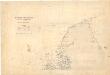
Museumskart 193: Sjøgrændsen fra bunden af Iddefjorden til Nord Hällsö og Gylte varda
1 : 50000 O. Stenberg | S. Müller Det kongelige Departement for udenrigske Sager, Handel, Sjøfart og Industri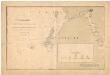
Museumskart 8: Sjøgrændsen fra bunden af Iddefjorden til Nord Hällsö og Gylte varde
1 : 50000
Jegerkorps nr 19: Kart over Idd, Enningdal og Aremark sogn, del 2
1 : 13330 Jean Henri Spørck
10A 8; 10A 12; 10B 5; 10B 9
1 : 50000 Collin
10B 5; 10B 9
1 : 50000 David Ebbesen | Oluf Gabriel Lund
2012-4 Kornsjö
1 : 50000 Norges Geografiske Oppmåling
Mil nr 1
1 : 10000
Mil nr 4
1 : 10000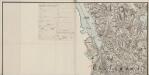
Mil nr 3
1 : 10000
Mil nr 2
1 : 10000
10A Hvaler
1 : 100000 Einar Sigurd Ween | Ole Tolstad
Trigonometrisk grunnlag, Squelet-Cart 65-3
Museumskart 5: Sveriges kust från Koster-öarna till Norska gränsen
1 : 100000 S. Müller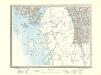
10A Hvaler
1 : 100000 Einar Sigurd Ween | Ole Tolstad
Kartblad 1-2: Vei-Cart over det Iddeske Compagnie District, versjon 2
Schielderup
Kartblad 1- Vei-Cart over det Iddeske Compagnie District; versjon 1
Schielderup
Norge 2: Aggershuus Leen Saaledes som det 1661 ved Commisarier er bleven delt
Gerhard Leijon Crantz | Johan Gustafsen Ørnevinge
Norge 2: Geometriscks Afritningh
U. J. From
Portefølje nr 10
1 : 100000