Maps of Åmot

Mil nr 205
1 : 10000 Carl Wendel Bremer
26C-12-vest
1 : 10000 Carl Wendel Bremer
26C 12
1 : 50000 Johannes Solem
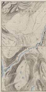
Fra Amundstad til Ørbekken
1 : 20000 J. H. Reichborn
1917-2 Rena
1 : 50000 Norges Geografiske Oppmåling
1917-2 Rena
1 : 50000 Statens kartverk
1917-2 Rena
1 : 50000 Norges Geografiske Oppmåling
1917-2 Rena
1 : 50000 Statens kartverk
1917-2 Rena
1 : 50000 Norges Geografiske Oppmåling
1917-2 Rena
1 : 50000 Statens kartverk
26C 11
1 : 50000 Johannes Solem
26C 11
1 : 50000 Johannes Solem
26C-12-øst
1 : 10000 Carl Wendel Bremer
Mil nr 204
1 : 10000 Carl Wendel Bremer
1917-2 Rena
1 : 50000 Statens kartverk
26C Åmot
1 : 100000 C. Pedersen | Arnt Magnus Andreassen Øgaard
26C Åmot
1 : 100000 Nicolai Franck | Arnt Magnus Andreassen Øgaard
26C Åmot
1 : 100000 C. Pedersen | Arnt Magnus Andreassen Øgaard
26C Åmot
1 : 100000 C. Pedersen | Arnt Magnus Andreassen Øgaard
26C Åmot
1 : 100000
26C Åmot
1 : 100000 Arnt Magnus Andreassen Øgaard | C. Pedersen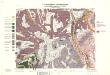
Geologisk kart 32a: Den Geologiske Undersøgelse, Rektangel 26 Åmot
1 : 100000 P. Krohn | Ths. Münster | Øgaard Norges geologiske undersøkelse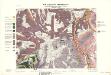
Geologisk kart 32b: Den Geologiske Undersøgelse, Rektangel 26 Åmot
1 : 100000 Øgaard | Ths. Münster | P. Krohn Norges geologiske undersøkelse
Portefølje nr 48
1 : 100000 Schilling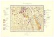
Geologisk kart 95: Stor-Elvdal
1 : 100000 Emil Moestue Norges geologiske undersøkelse
Kartblad 163 vest: Det Elverumske Skjeløber Compagnie; vestre del

Spesielle kart 22-6: Rena - Stai
1 : 400000 Albert Cammermeyer Forlag
Spesielle kart 103-7: Flötningskart over Glommens vassdrag
1 : 1000 Einar Sigurd Ween
Norge 117: Kart over Hedemarken; Toten og Søen Mjøsen
1 : 144000 N. S. Darre