Maps of Karasjok

2033-3 Bæivašgied'di
1 : 50000 Norges Geografiske Oppmåling
2033-3 Bæivašgied'di
1 : 50000 Statens kartverk
2033-3 Beaivvašgieddi
1 : 50000 Statens kartverk
2033-3 Baeivasgiedde
1 : 50000 Norges Geografiske Oppmåling
V7
1 : 100000 Knut Odin Damm
V7 Bæivasgiedde
1 : 100000 Arnt Magnus Andreassen Øgaard | H. C. Wanggård
V7 Bæivasgiedde
1 : 100000 Arnt Magnus Andreassen Øgaard | Einar Sigurd Ween
V7 Bæivasgiedde
1 : 100000
V7 Bæivasgiedde
1 : 100000 Arnt Magnus Andreassen Øgaard | Einar Sigurd Ween
V7
1 : 100000 Nicolay Caspary Ræder
V7 Bæivasgiedde
1 : 100000 Arnt Magnus Andreassen Øgaard | Einar Sigurd Ween
NRA GA 22
Thodal | Wetterstedt | Holm | Wessaman | Krogh | Halldin
W7
1 : 100000 Carl Ludvig Soelberg
V7 nordre del og V6 søndre del
1 : 100000 Albert Hansen
W7
1 : 100000 Finn Qvale
W7 Iskuras
1 : 100000 Ole Bernhard Tolstad | Carl Christian P. Olberg
2033-4 Iešjåkka
1 : 50000 Statens kartverk
2033-4 Iešjåkka
1 : 50000 Norges Geografiske Oppmåling
V7
1 : 100000 Jacob Ager Laurantzon
1933-2 Galbbajavrre
1 : 50000 Norges Geografiske Oppmåling
Statistikk 43-28-2: Bosettingskart over Karasjok. Blad 28
1 : 250000 Statistisk Sentralbyrå
Statistikk 43-28- Bosettingskart over Karasjok. Blad 28
1 : 250000 Statistisk Sentralbyrå
Finmarkens amt nr 53a: Kaafjord
1 : 20000 Fr. Löwenborg
Finmarkens amt 54c(1): Hammerfest med Maasà ̧ Præstegjeld
1 : 200000 Gerhard Munthe, Fredrik Rode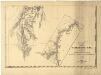
Statistikk 36-2 sør: Ethnigrafisk Kart over Finmarkens Amt No 2
1 : 200000 Jens Andreas Friis
Spesielle kart 122-12: Postkart over Norge
1 : 400000 Toralf à ̃yen
Statistikk 38-13: Bosettingskart over Finnmark og Troms. Blad 13
1 : 400000 Statistisk Sentralbyrå
Statistikk 38-15: Bosettingskart over Finnmark. Blad 15
1 : 400000 Statistisk Sentralbyrå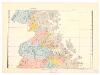
Spesielle kart 110-3: Hydrografisk kart over det nordlige Norge
1 : 500000 G. Sætren