Maps of Beiarn

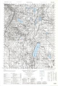
2028-1 Beiardal
1 : 50000 Norges Geografiske Oppmåling
2028-1 Beiardalen
1 : 50000 Norges Geografiske Oppmåling
2028-1 Beiardalen
1 : 50000 Statens kartverk
2028-1 Beiardalen
1 : 50000 Statens kartverk
K14 nordøstre del
1 : 50000 Marius Widerøe
K14 Beiardalen
1 : 100000 Ole Bernhard Tolstad | Ole Engh
K14 Beiardalen
1 : 100000 Ole Bernhard Tolstad | Ole Engh
K14 Beiardalen
1 : 100000 Ole Bernhard Tolstad | Ole Engh
K14 sørøstre del
1 : 50000 Christopher Fougner
K14 Beiardalen
1 : 100000
L14 Junkerdalen
1 : 100000
K13 Bodø
1 : 100000 Torgrim Lundtvedt | Ole Engh
2029-2 Skjerstad
1 : 50000 Norges Geografiske Oppmåling
2029-2 Misvær
1 : 50000 Statens kartverk
K14 nordvestre del
1 : 50000 Ole Jacob Broch
L14 nordvestre del
1 : 50000 Rasmus Larsen Hatledal
L14 nordvestre del
1 : 50000 Kjeld Andreas Bugge
K13 sørøstre del
1 : 50000 Erland Stenersen
L14 nordvestre del
1 : 50000 Oluf Gabriel Lund
2128-4 Junkerdal
1 : 50000 Norges Geografiske Oppmåling
Rana
1 : 250000 Bernh. Tolstad | O. Engh
Rana
1 : 250000 Bernh. Tolstad | O. Engh
Rana
1 : 250000 Bernh. Tolstad | O. Engh
Rana
1 : 250000 Bernh. Tolstad | O. Engh
Statistikk 43-22-2: Bosettingskart over Sulitjelma. Blad 22
1 : 250000 Statistisk Sentralbyrå
Statistikk 43-20- Bosettingskart over Mo i Rana. Blad 20
1 : 250000 Statistisk Sentralbyrå
Statistikk 43-20-2: Bosettingskart over Mo i Rana. Blad 20
1 : 250000 Statistisk Sentralbyrå
Statistikk 38-10: Bosettingskart over Nordland. Blad 10
1 : 400000 Statistisk Sentralbyrå
Spesielle kart 122-10: Postkart over Norge
1 : 400000 Toralf à ̃yen