Maps of Hurum

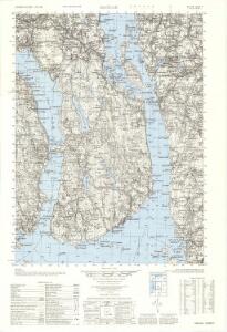
1814-2 Dröbak
1 : 50000 Norges Geografiske Oppmåling
1814-2 Dröbak
1 : 50000 Norges Geografiske Oppmåling
Museumskart 217-44: Specialkart over Kristianiafjorden fra Drammen og Drøbak til Bastø
1 : 50000 C. F. Wille | H. N. Bergh Den Geografiske Opmaaling
Kartblad 26-2: Det Huurumske Compagnie District; versjon 2

1814-2 Drøbak
1 : 50000 Statens kartverk
1814-2 Drøbak
1 : 50000 Statens kartverk
1814-2 Dröbak
1 : 50000 Norges Geografiske Oppmåling
1814-2 Drøbak
1 : 50000 Statens kartverk
14B 11; 14D 3
1 : 50000
14B 7
1 : 50000 C. F. Heyerdahl
Jegerkorps nr 11A: Kart over Aas, Krogstad, Vestby, Hob og Vaaler, vest
1 : 13000
14B 11
1 : 25000
14B 11 nv
1 : 25000 Harald Ingvar Johannessen | Ivar Aavatsmark
14B 7 nø
1 : 25000 Lorange | Gustaf Peter Grüner
14B 11 nø; 14B 12 nv; 14D 4 sv
1 : 25000 Johannes Solem
14B 12 nv
1 : 25000 Carl Axel Sigurd Sissener
14B 11 sø
1 : 25000 Mathias Andersen Ween
14B 7 nv; 14B 7 sv
1 : 25000 Nils Johannes Sejersted
14B 8 nv
1 : 25000 Vilhelm C. M. Ødegaard
14B 6 sø; 14B 7 sv
1 : 25000 Nicolai Caspary Ræder
Mil nr 39
1 : 10000 Gustav Adolph von Wahrendorff | Ramm | Hans Lemmich Juell
Mil nr 46
1 : 10000 Johan Henrich Ramm | Hans Lemmich Juell
14B 11 nø; 14B 11 nv
1 : 25000 Ole Tolstad
14B 11 sv
1 : 25000 Hildgaard
Trigonometrisk grunnlag, vedlegg 12: Fundament Mensul til Deel af Qvadrat-Miilen Nomer 39
1 : 20000 Hans Lemmich Juell | Carl Wendel Bremer
14B 12
1 : 40000 Hans Øvergaard
14B 12
1 : 20000 Hans Øvergaard
14B 8 sør
1 : 25000 Vilhelm C. M. Ødegaard
14D 3 øst; 14D 4 vest
1 : 25000 Johannes Solem