Maps of Kvænangen

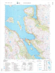
1734-1 Kvænangen
1 : 50000 Statens kartverk
1734-1 Kvænangen
1 : 50000 Norges Geografiske Oppmåling
1734-1 Kvænangen
1 : 50000 Norges Geografiske Oppmåling
1734-1 Kvænangen
1 : 50000 Statens kartverk
1734-1 Kvænangen
1 : 50000 Statens kartverk
Krokering nr 52
1 : 100000 Widerberg
Krokering nr 69
1 : 100000 Morgenstierne
Krokering nr 79
1 : 200000 Widerberg
Krokering nr 36
1 : 100000 Lund
T5 Kaafjord
1 : 100000 Ole Tolstad | C. Pedersen
93C 2; 93C 3; 93C 6; 93C 7
1 : 100000 Carl Oscar Munthe
T5 Kaafjord
1 : 100000 Ole Tolstad | C. Pedersen
Krokering nr 81
1 : 200000 Morgenstierne
T5 Kaafjord
1 : 100000 Ole Tolstad | H. C. Wanggård
S4 Bergsfjorden
1 : 100000 Ole Engh | Torgrim Lundtvedt
Krokering nr 76
1 : 100000 Lund
S4
1 : 100000 Finn Abrahamson
1735-2 Öksfjordjökulen
1 : 50000 Statens kartverk
93A 7; 93A 8; 93A 11
1 : 100000 Carl Oscar Munthe
T5
1 : 100000 Johan Ingolf Koren L'orange | Thorolf Bjørnstad
Krokering nr 51
1 : 100000 Widerberg
1734-4 Storslett
1 : 50000 Statens kartverk
1734-4 Nordreisa
1 : 50000 Statens kartverk
Geologiske kart 121-Z: Kart med magnetisk totalfelt. Nordreisa
1 : 250000 Norges geologiske undersøkelse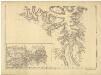
Statistikk 36-3 sør: Ethnigrafisk Kart over Finmarkens Amt No 3
1 : 200000 Jens Andreas Friis
Statistikk 43-27-2: Bosettingskart over Nordreisa. Blad 27
1 : 250000 Statistisk Sentralbyrå
Statistikk 43-27- Bosettingskart over Nordreisa. Blad 27
1 : 250000 Statistisk Sentralbyrå
Museumskart 217-16: Kart over Den Norske Kyst fra Kvalø og Grøtsund til Sørøen
1 : 50000 Due | G. L. Fehr | Rynning | Vibe | Hagerup Opmaalings Directionen
Museumskart 143: Kart over Den Norske Kyst fra Kvalø og Grøtsund til Sørøen
1 : 200000 Due | Rynning | Vibe | Hagerup