Maps of Grimstad

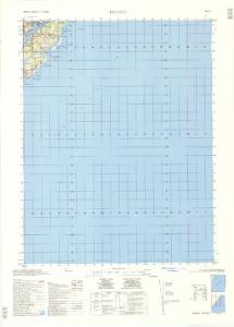
1611-1 Tromöy
1 : 50000 Norges Geografiske Oppmåling
1611-1 Tromøy
1 : 50000 Statens kartverk
1611-1 Tromöy
1 : 50000 Norges Geografiske Oppmåling
1611-1 Tromöy
1 : 50000 Norges Geografiske Oppmåling
1611-1 Tromøy
1 : 50000 Statens kartverk
Museumskart 54: Carte ofver Arendals Haufn
1 : 20000
Saltrød i Arendal
1 : 3000 Krum
Krøgenes i Arendal
1 : 3000 Krum
Rævesand i Arendal
1 : 3000 Krum
Songe
1 : 3000 Krum
5B Grimstad
1 : 100000 H. Hagen | Arnt Magnus Andreassen Øgaard
5B Grimstad
1 : 100000 H. C. Wanggård | Arnt Magnus Andreassen Øgaard
5B Grimstad
1 : 100000
5B Grimstad
1 : 100000 H. Hagen | Arnt Magnus Andreassen Øgaard
5B 9 5B 10
1 : 50000 Johannes Solem
1612-2 Tvedestrand
1 : 50000 Norges Geografiske Oppmåling
5D 2 5D 3 5D 7 5D 8
1 : 50000 Johannes Solem
Arendal
1 : 100000 P. M. Bye og Co. AS Oslo
5B 5 5B 9 5B 10
1 : 50000 Ph. Sissener
1612-2 Tvedestrand
1 : 50000 Norges Geografiske Oppmåling
E39-10-sø/4, E39-10-s/2
1 : 50000 Nils Roer
5D 2 5D 3 5D 6 5D 7
1 : 50000 Johan Sissener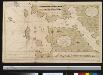
Nieuwe afteekening vant Gat en het eijland Maerdou of Merdøe aen de cust van Noorwegen
Norway Gerard van Keulen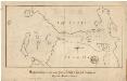
Museumskart 6 Miswiisende Kaart over Arendals havn og Indløbet til same samt Udhavnene
1 : 10000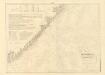
Museumskart 217-20: Kart over Den Norske Kyst fra Jomfruland og Kragerø til Christiansand
1 : 50000 Schie | C. Diriks | H. Wille Opmaalings Directionen
Geologiske kart 121-V2: Kart med magnetisk totalfelt. Arendal
1 : 250000 Norges geologiske undersøkelse
Trigonometrisk grunnlag, Squelet-Cart 65-1
Museumskart 217-24: Kart over Den Norske Kyst fra Arendal til Christiansand
1 : 50000 H. Wille | C. Diriks | Vibe Opmaalings Directionen
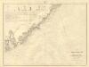
Trigonometrisk grunnlag, Squelet-Cart 19-2: Kysten fra Kragerø til Tromøy
Niels Andreas Wibe | B. Aubert